Yondó geodata
Yondó (Antioquia) is a seat of a second-order administrative division; located in Colombia in America/Bogota (GMT-5) time zone. With population of 7,516 people, there are 389 cities with bigger population in this country. Compared to other cities in Colombia, 74.3% of cities are located further ↓South; 67.3% of cities are located further ←West and 83.8% of cities have higher elevation than Yondó. Note1


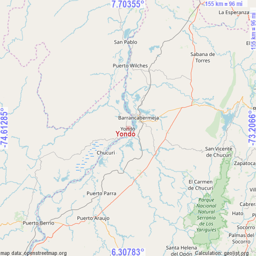
Yondó GPS coordinates[2]
7° 0' 22.356" North, 73° 54' 34.992" West
| Map corner | latitude | longitude |
|---|---|---|
| Upper-left | 7.70355°, | -74.61285° |
| Center: | 7.00621°, | -73.90972° |
| Lower-right: | 6.30783°, | -73.2066° |
| Map W x H: | 155.2×155.2 km | = 96.4×96.4mi |
| max Lat: | 13.38166° ⇑25.7% North |
| Yondó: | 7.00621° |
| min Lat: | ⇓74.3% South -4.21528° |
| min Long | Yondó | max Long |
| -81.70636° | -73.90972° | -67.06996° |
| W 67.3%⇐ | ⇒32.7% E |
Elevation
Elevation of Yondó is 72 m = 236 ft, and this is 1077.3 m = 3534 ft below average elevation for this country.
| Max E: |
3342 m = 10965 ft | 83.8% |
| Avg. | 1149.3 m = 3771 ft | |
| Yondó | 72 m = 236 ft | |
Min E: |
1 m = 3 ft | 16.2% |
See also: Colombia elevation on elevation.city.
Geographical zone
Yondó is located in North Torrid zone (between Equator and Tropic of Cancer). Distance of Equator is 779 km =484 mi to South.| Distance of | km | miles | from Yondó |
|---|---|---|---|
| North Pole | 9228 | 5734 | to North |
| Arctic Circle | 6622.2 | 4114.8 | to North |
| Tropic Cancer | 1826.9 | 1135.2 | to North |
| Equator | 779 | 484 | to South |


Nearby cities:
15 places around Yondó: (largest is in red/bold)
• Barrancabermeja
8.9 km =5.5 mi,  42°
42°
• Betulia
70.1 km =43.6 mi,  99°
99°
• Cantagallo
41.5 km =25.8 mi,  359°
359°
• Cimitarra
77.1 km =47.9 mi,  183°
183°
• El Carmen de Chucurí
55.8 km =34.7 mi,  127°
127°
• Galán
79.9 km =49.6 mi,  120°
120°
• Lebrija
77.3 km =48 mi,  81°
81°
• Puerto Berrío
79 km =49.1 mi,  223°
223°
• Puerto Parra
42.7 km =26.5 mi,  202°
202°
• Puerto Wilches
38.1 km =23.7 mi,  2°
2°
• Sabana de Torres
62.6 km =38.9 mi,  46°
46°
• San Pablo
52.4 km =32.6 mi, 358°
• San Vicente de Chucurí
56.9 km =35.4 mi, 104°
• Santa Helena del Opón
80.8 km =50.2 mi,  156°
156°
• Zapatoca
74 km =46 mi,  106°
106°
Sources, notices
• [Note1] Compared only with cities in Colombia existing in our database
• [Src1] Map data: © OpenStreetMap contributors (CC-BY-SA)
• [Src2] Other city data from geonames.org with taken over terms of usage.
• [Src3] Geographical zone / Annual Mean Temperature by Robert A. Rohde @ Wikipedia
