Puerto Wilches geodata
Puerto Wilches (Santander) is a seat of a second-order administrative division; located in Colombia in America/Bogota (GMT-5) time zone. With population of 13,705 people, there are 235 cities with bigger population in this country. Compared to other cities in Colombia, 77.2% of cities are located further ↓South; 67.6% of cities are located further ←West and 84.3% of cities have higher elevation than Puerto Wilches. Note1


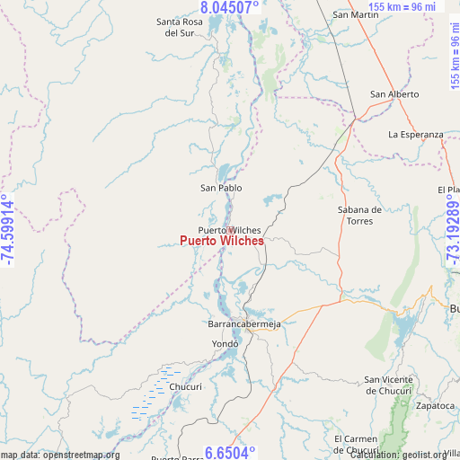
Puerto Wilches GPS coordinates[2]
7° 20' 53.808" North, 73° 53' 45.636" West
| Map corner | latitude | longitude |
|---|---|---|
| Upper-left | 8.04507°, | -74.59914° |
| Center: | 7.34828°, | -73.89601° |
| Lower-right: | 6.6504°, | -73.19289° |
| Map W x H: | 155.1×155.1 km | = 96.4×96.4mi |
| max Lat: | 13.38166° ⇑22.8% North |
| Puerto Wilches: | 7.34828° |
| min Lat: | ⇓77.2% South -4.21528° |
| min Long | Puerto Wilches | max Long |
| -81.70636° | -73.89601° | -67.06996° |
| W 67.6%⇐ | ⇒32.4% E |
Elevation
Elevation of Puerto Wilches is 67 m = 220 ft, and this is 1082.3 m = 3551 ft below average elevation for this country.
| Max E: |
3342 m = 10965 ft | 84.3% |
| Avg. | 1149.3 m = 3771 ft | |
| Puerto Wilches | 67 m = 220 ft | |
Min E: |
1 m = 3 ft | 15.7% |
See also: Colombia elevation on elevation.city.
Geographical zone
Puerto Wilches is located in North Torrid zone (between Equator and Tropic of Cancer). Distance of Equator is 817.1 km =507.7 mi to South.| Distance of | km | miles | from Puerto Wilches |
|---|---|---|---|
| North Pole | 9190 | 5710.4 | to North |
| Arctic Circle | 6584.1 | 4091.2 | to North |
| Tropic Cancer | 1788.9 | 1111.6 | to North |
| Equator | 817.1 | 507.7 | to South |


Nearby cities:
15 places around Puerto Wilches: (largest is in red/bold)
• Barrancabermeja
31.8 km =19.8 mi,  171°
171°
• Betulia
83.9 km =52.1 mi,  126°
126°
• Cantagallo
4.1 km =2.5 mi,  328°
328°
• El Playón
77.6 km =48.2 mi,  79°
79°
• La Esperanza
70.6 km =43.9 mi,  62°
62°
• Lebrija
79.2 km =49.2 mi,  109°
109°
• Puerto Parra
79.5 km =49.4 mi,  192°
192°
• Rionegro
82.8 km =51.4 mi,  96°
96°
• Sabana de Torres
44.4 km =27.6 mi, 83°
• San Alberto
72 km =44.7 mi,  50°
50°
• San Pablo
14.7 km =9.1 mi,  348°
348°
• San Vicente de Chucurí
74.7 km =46.4 mi, 134°
• Santa Rosa del Sur
70.7 km =43.9 mi, 345°
• Simití
68 km =42.3 mi,  355°
355°
• Yondó
38.1 km =23.7 mi,  182°
182°
Sources, notices
• [Note1] Compared only with cities in Colombia existing in our database
• [Src1] Map data: © OpenStreetMap contributors (CC-BY-SA)
• [Src2] Other city data from geonames.org with taken over terms of usage.
• [Src3] Geographical zone / Annual Mean Temperature by Robert A. Rohde @ Wikipedia
