Morales geodata
Morales (Bolívar) is a seat of a second-order administrative division; located in Colombia in America/Bogota (GMT-5) time zone. With population of 20,375 people, there are 174 cities with bigger population in this country. Compared to other cities in Colombia, 82.4% of cities are located further ↓South; 68.2% of cities are located further ←West and 87.5% of cities have higher elevation than Morales. Note1


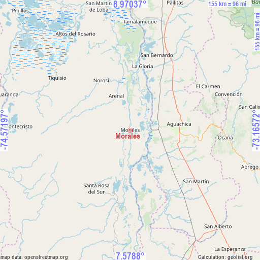
Morales GPS coordinates[2]
8° 16' 30.72" North, 73° 52' 7.824" West
| Map corner | latitude | longitude |
|---|---|---|
| Upper-left | 8.97037°, | -74.57197° |
| Center: | 8.2752°, | -73.86884° |
| Lower-right: | 7.5788°, | -73.16572° |
| Map W x H: | 154.7×154.7 km | = 96.1×96.1mi |
| max Lat: | 13.38166° ⇑17.6% North |
| Morales: | 8.2752° |
| min Lat: | ⇓82.4% South -4.21528° |
| min Long | Morales | max Long |
| -81.70636° | -73.86884° | -67.06996° |
| W 68.2%⇐ | ⇒31.8% E |
Elevation
Elevation of Morales is 42 m = 138 ft, and this is 1107.3 m = 3633 ft below average elevation for this country.
| Max E: |
3342 m = 10965 ft | 87.5% |
| Avg. | 1149.3 m = 3771 ft | |
| Morales | 42 m = 138 ft | |
Min E: |
1 m = 3 ft | 12.5% |
See also: Colombia elevation on elevation.city.
Geographical zone
Morales is located in North Torrid zone (between Equator and Tropic of Cancer). Distance of Equator is 920.1 km =571.7 mi to South.| Distance of | km | miles | from Morales |
|---|---|---|---|
| North Pole | 9086.9 | 5646.3 | to North |
| Arctic Circle | 6481.1 | 4027.2 | to North |
| Tropic Cancer | 1685.8 | 1047.5 | to North |
| Equator | 920.1 | 571.7 | to South |


Nearby cities:
15 places around Morales: (largest is in red/bold)
• Aguachica
28 km =17.4 mi,  82°
82°
• Arenal
22 km =13.7 mi,  338°
338°
• El Carmen
53.2 km =33.1 mi,  60°
60°
• Gamarra
14.9 km =9.3 mi,  69°
69°
• González
55.3 km =34.4 mi, 76°
• La Gloria
38.9 km =24.2 mi,  10°
10°
• Norosí
33.6 km =20.9 mi,  326°
326°
• Pelaya
51.1 km =31.8 mi,  26°
26°
• Regidor
43.7 km =27.2 mi, 6°
• Río Viejo
34.9 km =21.7 mi, 5°
• Río de Oro
53.3 km =33.1 mi,  88°
88°
• San Martín
49.8 km =30.9 mi,  127°
127°
• Santa Rosa del Sur
40.1 km =24.9 mi,  210°
210°
• Simití
36.2 km =22.5 mi,  193°
193°
• Tiquisio
53.5 km =33.2 mi,  305°
305°
Sources, notices
• [Note1] Compared only with cities in Colombia existing in our database
• [Src1] Map data: © OpenStreetMap contributors (CC-BY-SA)
• [Src2] Other city data from geonames.org with taken over terms of usage.
• [Src3] Geographical zone / Annual Mean Temperature by Robert A. Rohde @ Wikipedia
