San José geodata
San José (Nariño) is a seat of a second-order administrative division; located in Colombia in America/Bogota (GMT-5) time zone. With population of 1,772 people, there are 827 cities with bigger population in this country. Compared to other cities in Colombia, 92% of cities are located further ↑North; 99.4% of cities are located further →East and 87.8% of cities have higher elevation than San José. Note1


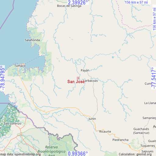
San José GPS coordinates[2]
1° 41' 47.724" North, 78° 14' 41.352" West
| Map corner | latitude | longitude |
|---|---|---|
| Upper-left | 2.39926°, | -78.94795° |
| Center: | 1.69659°, | -78.24482° |
| Lower-right: | 0.99366°, | -77.5417° |
| Map W x H: | 156.3×156.3 km | = 97.1×97.1mi |
| max Lat: | 13.38166° ⇑92% North |
| San José: | 1.69659° |
| min Lat: | ⇓8% South -4.21528° |
| min Long | San José | max Long |
| -81.70636° | -78.24482° | -67.06996° |
| W 0.6%⇐ | ⇒99.4% E |
Elevation
Elevation of San José is 39 m = 128 ft, and this is 1110.3 m = 3643 ft below average elevation for this country.
| Max E: |
3342 m = 10965 ft | 87.8% |
| Avg. | 1149.3 m = 3771 ft | |
| San José | 39 m = 128 ft | |
Min E: |
1 m = 3 ft | 12.2% |
See also: Colombia elevation on elevation.city.
Geographical zone
San José is located in North Torrid zone (between Equator and Tropic of Cancer). Distance of Equator is 188.6 km =117.2 mi to South.| Distance of | km | miles | from San José |
|---|---|---|---|
| North Pole | 9818.4 | 6100.9 | to North |
| Arctic Circle | 7212.5 | 4481.6 | to North |
| Tropic Cancer | 2417.3 | 1502 | to North |
| Equator | 188.6 | 117.2 | to South |


Nearby cities:
15 places around San José: (largest is in red/bold)
• Barbacoas
12 km =7.5 mi,  103°
103°
• Bocas de Satinga
73 km =45.4 mi,  352°
352°
• Cumbitara
74.3 km =46.2 mi,  94°
94°
• Guachavés
82.2 km =51.1 mi,  129°
129°
• La Llanada
77.9 km =48.4 mi,  108°
108°
• La Tola
78.4 km =48.7 mi,  4°
4°
• Payán
10.4 km =6.5 mi,  41°
41°
• Piedrancha
74.8 km =46.5 mi,  145°
145°
• Policarpa
87.6 km =54.4 mi, 94°
• Providencia
87.9 km =54.6 mi, 99°
• Ricaurte
60.2 km =37.4 mi, 152°
• Salahonda
59.8 km =37.2 mi,  309°
309°
• Samaniego
82.4 km =51.2 mi,  118°
118°
• Sotomayor
83.5 km =51.9 mi, 105°
• Tumaco
61.8 km =38.4 mi,  279°
279°
Sources, notices
• [Note1] Compared only with cities in Colombia existing in our database
• [Src1] Map data: © OpenStreetMap contributors (CC-BY-SA)
• [Src2] Other city data from geonames.org with taken over terms of usage.
• [Src3] Geographical zone / Annual Mean Temperature by Robert A. Rohde @ Wikipedia
