Payán geodata
Payán (Nariño) is a seat of a second-order administrative division; located in Colombia in America/Bogota (GMT-5) time zone. With population of 2,892 people, there are 693 cities with bigger population in this country. Compared to other cities in Colombia, 91.6% of cities are located further ↑North; 99.2% of cities are located further →East and 82.9% of cities have higher elevation than Payán. Note1


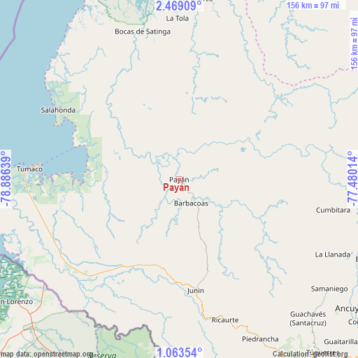
Payán GPS coordinates[2]
1° 45' 59.22" North, 78° 10' 59.736" West
| Map corner | latitude | longitude |
|---|---|---|
| Upper-left | 2.46909°, | -78.88639° |
| Center: | 1.76645°, | -78.18326° |
| Lower-right: | 1.06354°, | -77.48014° |
| Map W x H: | 156.3×156.3 km | = 97.1×97.1mi |
| max Lat: | 13.38166° ⇑91.6% North |
| Payán: | 1.76645° |
| min Lat: | ⇓8.4% South -4.21528° |
| min Long | Payán | max Long |
| -81.70636° | -78.18326° | -67.06996° |
| W 0.8%⇐ | ⇒99.2% E |
Elevation
Elevation of Payán is 85 m = 279 ft, and this is 1064.3 m = 3492 ft below average elevation for this country.
| Max E: |
3342 m = 10965 ft | 82.9% |
| Avg. | 1149.3 m = 3771 ft | |
| Payán | 85 m = 279 ft | |
Min E: |
1 m = 3 ft | 17.1% |
See also: Colombia elevation on elevation.city.
Geographical zone
Payán is located in North Torrid zone (between Equator and Tropic of Cancer). Distance of Equator is 196.4 km =122 mi to South.| Distance of | km | miles | from Payán |
|---|---|---|---|
| North Pole | 9810.7 | 6096.1 | to North |
| Arctic Circle | 7204.8 | 4476.9 | to North |
| Tropic Cancer | 2409.5 | 1497.2 | to North |
| Equator | 196.4 | 122 | to South |


Nearby cities:
15 places around Payán: (largest is in red/bold)
• Barbacoas
11.6 km =7.2 mi,  155°
155°
• Bocas de Satinga
66.6 km =41.4 mi,  346°
346°
• Cumbitara
68.5 km =42.6 mi,  101°
101°
• El Charco
79.7 km =49.5 mi,  5°
5°
• Iscuandé
79.4 km =49.3 mi,  16°
16°
• La Llanada
74.5 km =46.3 mi,  115°
115°
• La Tola
70.4 km =43.7 mi,  359°
359°
• Piedrancha
78 km =48.5 mi,  153°
153°
• Policarpa
81.9 km =50.9 mi, 100°
• Ricaurte
64.7 km =40.2 mi, 161°
• Salahonda
61 km =37.9 mi,  299°
299°
• Samaniego
80.8 km =50.2 mi,  126°
126°
• San José
10.4 km =6.5 mi,  221°
221°
• Sotomayor
79.5 km =49.4 mi,  112°
112°
• Tumaco
67.8 km =42.1 mi,  272°
272°
Sources, notices
• [Note1] Compared only with cities in Colombia existing in our database
• [Src1] Map data: © OpenStreetMap contributors (CC-BY-SA)
• [Src2] Other city data from geonames.org with taken over terms of usage.
• [Src3] Geographical zone / Annual Mean Temperature by Robert A. Rohde @ Wikipedia
