Puerto Parra geodata
Puerto Parra (Santander) is a seat of a second-order administrative division; located in Colombia in America/Bogota (GMT-5) time zone. With population of 1,448 people, there are 875 cities with bigger population in this country. Compared to other cities in Colombia, 70.7% of cities are located further ↓South; 63.8% of cities are located further ←West and 81.5% of cities have higher elevation than Puerto Parra. Note1


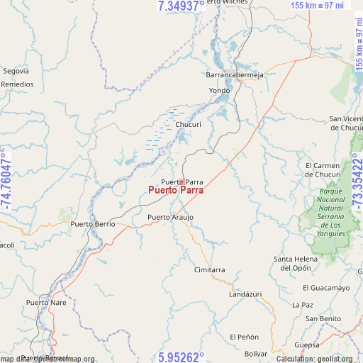
Puerto Parra GPS coordinates[2]
6° 39' 5.364" North, 74° 3' 26.424" West
| Map corner | latitude | longitude |
|---|---|---|
| Upper-left | 7.34937°, | -74.76047° |
| Center: | 6.65149°, | -74.05734° |
| Lower-right: | 5.95262°, | -73.35422° |
| Map W x H: | 155.3×155.3 km | = 96.5×96.5mi |
| max Lat: | 13.38166° ⇑29.3% North |
| Puerto Parra: | 6.65149° |
| min Lat: | ⇓70.7% South -4.21528° |
| min Long | Puerto Parra | max Long |
| -81.70636° | -74.05734° | -67.06996° |
| W 63.8%⇐ | ⇒36.2% E |
Elevation
Elevation of Puerto Parra is 96 m = 315 ft, and this is 1053.3 m = 3456 ft below average elevation for this country.
| Max E: |
3342 m = 10965 ft | 81.5% |
| Avg. | 1149.3 m = 3771 ft | |
| Puerto Parra | 96 m = 315 ft | |
Min E: |
1 m = 3 ft | 18.5% |
See also: Colombia elevation on elevation.city.
Geographical zone
Puerto Parra is located in North Torrid zone (between Equator and Tropic of Cancer). Distance of Equator is 739.6 km =459.6 mi to South.| Distance of | km | miles | from Puerto Parra |
|---|---|---|---|
| North Pole | 9267.5 | 5758.6 | to North |
| Arctic Circle | 6661.6 | 4139.3 | to North |
| Tropic Cancer | 1866.3 | 1159.7 | to North |
| Equator | 739.6 | 459.6 | to South |


Nearby cities:
15 places around Puerto Parra: (largest is in red/bold)
• Barrancabermeja
51.2 km =31.8 mi,  25°
25°
• Bolívar
80.2 km =49.8 mi,  156°
156°
• Cimitarra
39.3 km =24.4 mi, 162°
• Contratación
76 km =47.2 mi,  121°
121°
• El Carmen de Chucurí
60.5 km =37.6 mi,  85°
85°
• El Guacamayo
76.7 km =47.7 mi,  126°
126°
• El Peñón
71.5 km =44.4 mi, 158°
• La Paz
73.7 km =45.8 mi,  135°
135°
• Landázuri
55.3 km =34.4 mi,  150°
150°
• Puerto Berrío
42.1 km =26.2 mi,  245°
245°
• Puerto Wilches
79.5 km =49.4 mi,  12°
12°
• San Vicente de Chucurí
75.9 km =47.2 mi,  70°
70°
• Santa Helena
65.3 km =40.6 mi, 126°
• Santa Helena del Opón
59.7 km =37.1 mi, 125°
• Yondó
42.7 km =26.5 mi,  22°
22°
Sources, notices
• [Note1] Compared only with cities in Colombia existing in our database
• [Src1] Map data: © OpenStreetMap contributors (CC-BY-SA)
• [Src2] Other city data from geonames.org with taken over terms of usage.
• [Src3] Geographical zone / Annual Mean Temperature by Robert A. Rohde @ Wikipedia
