Puebloviejo geodata
Puebloviejo (Magdalena) is a seat of a second-order administrative division; located in Colombia in America/Bogota (GMT-5) time zone. With population of 13,523 people, there are 238 cities with bigger population in this country. Compared to other cities in Colombia, 99.1% of cities are located further ↓South; 60.6% of cities are located further ←West and 99.2% of cities have higher elevation than Puebloviejo. Note1


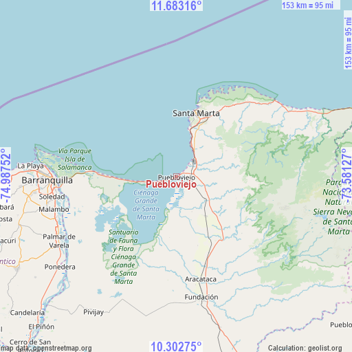
Puebloviejo GPS coordinates[2]
10° 59' 37.536" North, 74° 17' 3.804" West
| Map corner | latitude | longitude |
|---|---|---|
| Upper-left | 11.68316°, | -74.98752° |
| Center: | 10.99376°, | -74.28439° |
| Lower-right: | 10.30275°, | -73.58127° |
| Map W x H: | 153.5×153.5 km | = 95.4×95.4mi |
| max Lat: | 13.38166° ⇑0.9% North |
| Puebloviejo: | 10.99376° |
| min Lat: | ⇓99.1% South -4.21528° |
| min Long | Puebloviejo | max Long |
| -81.70636° | -74.28439° | -67.06996° |
| W 60.6%⇐ | ⇒39.4% E |
Elevation
Elevation of Puebloviejo is 4 m = 13 ft, and this is 1145.3 m = 3758 ft below average elevation for this country.
| Max E: |
3342 m = 10965 ft | 99.2% |
| Avg. | 1149.3 m = 3771 ft | |
| Puebloviejo | 4 m = 13 ft | |
Min E: |
1 m = 3 ft | 0.8% |
See also: Colombia elevation on elevation.city.
Geographical zone
Puebloviejo is located in North Torrid zone (between Equator and Tropic of Cancer). Distance of Equator is 1222.4 km =759.6 mi to South.| Distance of | km | miles | from Puebloviejo |
|---|---|---|---|
| North Pole | 8784.7 | 5458.6 | to North |
| Arctic Circle | 6178.8 | 3839.3 | to North |
| Tropic Cancer | 1383.5 | 859.7 | to North |
| Equator | 1222.4 | 759.6 | to South |


Nearby cities:
15 places around Puebloviejo: (largest is in red/bold)
• Aracataca
45.9 km =28.5 mi,  166°
166°
• Barranquilla
54.3 km =33.7 mi,  267°
267°
• Ciénaga
4.3 km =2.7 mi,  69°
69°
• El Retén
42.6 km =26.5 mi,  177°
177°
• Fundación
53.7 km =33.4 mi, 168°
• Malambo
55.5 km =34.5 mi,  254°
254°
• Palmar de Varela
58.5 km =36.4 mi,  241°
241°
• Ponedera
64.4 km =40 mi,  232°
232°
• Prado-Sevilla
30.1 km =18.7 mi,  148°
148°
• Remolino
57.2 km =35.5 mi, 235°
• Sabanagrande
56.7 km =35.2 mi, 246°
• Santa Marta
29 km =18 mi,  18°
18°
• Santo Tomás
57.7 km =35.9 mi, 242°
• Sitionuevo
53.4 km =33.2 mi, 243°
• Soledad
53.1 km =33 mi,  260°
260°
Sources, notices
• [Note1] Compared only with cities in Colombia existing in our database
• [Src1] Map data: © OpenStreetMap contributors (CC-BY-SA)
• [Src2] Other city data from geonames.org with taken over terms of usage.
• [Src3] Geographical zone / Annual Mean Temperature by Robert A. Rohde @ Wikipedia
