El Retén geodata
El Retén (Magdalena) is a seat of a second-order administrative division; located in Colombia in America/Bogota (GMT-5) time zone. With population of 15,901 people, there are 215 cities with bigger population in this country. Compared to other cities in Colombia, 96.8% of cities are located further ↓South; 60.7% of cities are located further ←West and 91.5% of cities have higher elevation than El Retén. Note1


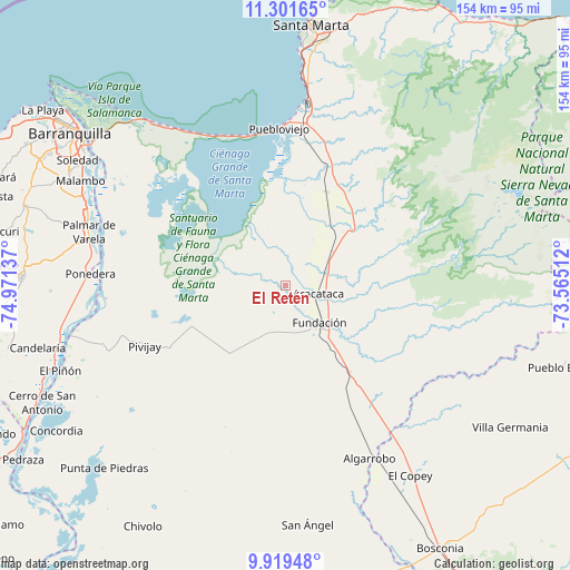
El Retén GPS coordinates[2]
10° 36' 40.86" North, 74° 16' 5.664" West
| Map corner | latitude | longitude |
|---|---|---|
| Upper-left | 11.30165°, | -74.97137° |
| Center: | 10.61135°, | -74.26824° |
| Lower-right: | 9.91948°, | -73.56512° |
| Map W x H: | 153.7×153.7 km | = 95.5×95.5mi |
| max Lat: | 13.38166° ⇑3.2% North |
| El Retén: | 10.61135° |
| min Lat: | ⇓96.8% South -4.21528° |
| min Long | El Retén | max Long |
| -81.70636° | -74.26824° | -67.06996° |
| W 60.7%⇐ | ⇒39.3% E |
Elevation
Elevation of El Retén is 24 m = 79 ft, and this is 1125.3 m = 3692 ft below average elevation for this country.
| Max E: |
3342 m = 10965 ft | 91.5% |
| Avg. | 1149.3 m = 3771 ft | |
| El Retén | 24 m = 79 ft | |
Min E: |
1 m = 3 ft | 8.5% |
See also: Colombia elevation on elevation.city.
Geographical zone
El Retén is located in North Torrid zone (between Equator and Tropic of Cancer). Distance of Equator is 1179.9 km =733.2 mi to South.| Distance of | km | miles | from El Retén |
|---|---|---|---|
| North Pole | 8827.2 | 5485 | to North |
| Arctic Circle | 6221.3 | 3865.7 | to North |
| Tropic Cancer | 1426 | 886.1 | to North |
| Equator | 1179.9 | 733.2 | to South |


Nearby cities:
15 places around El Retén: (largest is in red/bold)
• Algarrobo
52.4 km =32.6 mi,  154°
154°
• Algarrobo
57.9 km =36 mi,  215°
215°
• Aracataca
8.8 km =5.5 mi,  104°
104°
• Ariguaní
49.7 km =30.9 mi,  143°
143°
• Ciénaga
44.1 km =27.4 mi,  2°
2°
• Fundación
13.6 km =8.5 mi, 137°
• Palmar de Varela
55 km =34.2 mi,  285°
285°
• Pivijay
41.5 km =25.8 mi,  246°
246°
• Ponedera
53.2 km =33.1 mi,  273°
273°
• Prado-Sevilla
22 km =13.7 mi,  39°
39°
• Puebloviejo
42.6 km =26.5 mi,  357°
357°
• Remolino
50 km =31.1 mi,  281°
281°
• Sabanagrande
57.4 km =35.7 mi, 290°
• Santo Tomás
55.6 km =34.5 mi, 287°
• Sitionuevo
52.7 km =32.7 mi, 290°
Sources, notices
• [Note1] Compared only with cities in Colombia existing in our database
• [Src1] Map data: © OpenStreetMap contributors (CC-BY-SA)
• [Src2] Other city data from geonames.org with taken over terms of usage.
• [Src3] Geographical zone / Annual Mean Temperature by Robert A. Rohde @ Wikipedia
