Ciénaga geodata
Ciénaga (Magdalena) is a seat of a second-order administrative division; located in Colombia in America/Bogota (GMT-5) time zone. With population of 88,311 people, there are 45 cities with bigger population in this country. Compared to other cities in Colombia, 99.1% of cities are located further ↓South; 61.2% of cities are located further ←West and 98.9% of cities have higher elevation than Ciénaga. Note1


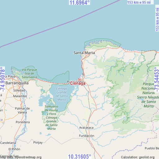
Ciénaga GPS coordinates[2]
11° 0' 25.308" North, 74° 14' 51.54" West
| Map corner | latitude | longitude |
|---|---|---|
| Upper-left | 11.6964°, | -74.95078° |
| Center: | 11.00703°, | -74.24765° |
| Lower-right: | 10.31605°, | -73.54453° |
| Map W x H: | 153.5×153.5 km | = 95.4×95.4mi |
| max Lat: | 13.38166° ⇑0.9% North |
| Ciénaga: | 11.00703° |
| min Lat: | ⇓99.1% South -4.21528° |
| min Long | Ciénaga | max Long |
| -81.70636° | -74.24765° | -67.06996° |
| W 61.2%⇐ | ⇒38.8% E |
Elevation
Elevation of Ciénaga is 5 m = 16 ft, and this is 1144.3 m = 3754 ft below average elevation for this country.
| Max E: |
3342 m = 10965 ft | 98.9% |
| Avg. | 1149.3 m = 3771 ft | |
| Ciénaga | 5 m = 16 ft | |
Min E: |
1 m = 3 ft | 1.1% |
See also: Ciénaga elevation on elevation.city.
Geographical zone
Ciénaga is located in North Torrid zone (between Equator and Tropic of Cancer). Distance of Equator is 1223.9 km =760.5 mi to South.| Distance of | km | miles | from Ciénaga |
|---|---|---|---|
| North Pole | 8783.2 | 5457.6 | to North |
| Arctic Circle | 6177.3 | 3838.4 | to North |
| Tropic Cancer | 1382.1 | 858.8 | to North |
| Equator | 1223.9 | 760.5 | to South |


Nearby cities:
15 places around Ciénaga: (largest is in red/bold)
• Aracataca
46.6 km =29 mi,  172°
172°
• Barranquilla
58.4 km =36.3 mi,  265°
265°
• El Retén
44.1 km =27.4 mi,  182°
182°
• Fundación
54.5 km =33.9 mi, 172°
• Malambo
59.7 km =37.1 mi,  254°
254°
• Palmar de Varela
62.8 km =39 mi,  241°
241°
• Ponedera
68.5 km =42.6 mi,  233°
233°
• Prado-Sevilla
29.6 km =18.4 mi,  156°
156°
• Puebloviejo
4.3 km =2.7 mi, 249°
• Remolino
61.4 km =38.2 mi, 236°
• Sabanagrande
60.9 km =37.8 mi, 246°
• Santa Marta
26.5 km =16.5 mi,  11°
11°
• Santo Tomás
61.9 km =38.5 mi, 243°
• Sitionuevo
57.6 km =35.8 mi, 243°
• Soledad
57.3 km =35.6 mi,  260°
260°
Sources, notices
• [Note1] Compared only with cities in Colombia existing in our database
• [Src1] Map data: © OpenStreetMap contributors (CC-BY-SA)
• [Src2] Other city data from geonames.org with taken over terms of usage.
• [Src3] Geographical zone / Annual Mean Temperature by Robert A. Rohde @ Wikipedia
