Aracataca geodata
Aracataca (Magdalena) is a seat of a second-order administrative division; located in Colombia in America/Bogota (GMT-5) time zone. With population of 27,704 people, there are 131 cities with bigger population in this country. Compared to other cities in Colombia, 96.6% of cities are located further ↓South; 62.1% of cities are located further ←West and 88.5% of cities have higher elevation than Aracataca. Note1


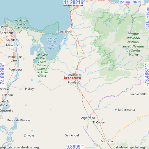
Aracataca GPS coordinates[2]
10° 35' 30.516" North, 74° 11' 23.388" West
| Map corner | latitude | longitude |
|---|---|---|
| Upper-left | 11.28216°, | -74.89296° |
| Center: | 10.59181°, | -74.18983° |
| Lower-right: | 9.8999°, | -73.48671° |
| Map W x H: | 153.7×153.7 km | = 95.5×95.5mi |
| max Lat: | 13.38166° ⇑3.4% North |
| Aracataca: | 10.59181° |
| min Lat: | ⇓96.6% South -4.21528° |
| min Long | Aracataca | max Long |
| -81.70636° | -74.18983° | -67.06996° |
| W 62.1%⇐ | ⇒37.9% E |
Elevation
Elevation of Aracataca is 37 m = 121 ft, and this is 1112.3 m = 3649 ft below average elevation for this country.
| Max E: |
3342 m = 10965 ft | 88.5% |
| Avg. | 1149.3 m = 3771 ft | |
| Aracataca | 37 m = 121 ft | |
Min E: |
1 m = 3 ft | 11.5% |
See also: Colombia elevation on elevation.city.
Geographical zone
Aracataca is located in North Torrid zone (between Equator and Tropic of Cancer). Distance of Equator is 1177.7 km =731.8 mi to South.| Distance of | km | miles | from Aracataca |
|---|---|---|---|
| North Pole | 8829.4 | 5486.3 | to North |
| Arctic Circle | 6223.5 | 3867.1 | to North |
| Tropic Cancer | 1428.2 | 887.4 | to North |
| Equator | 1177.7 | 731.8 | to South |


Nearby cities:
15 places around Aracataca: (largest is in red/bold)
• Algarrobo
47.3 km =29.4 mi,  162°
162°
• Algarrobo
61.7 km =38.3 mi,  223°
223°
• Ariguaní
43.3 km =26.9 mi,  151°
151°
• Ciénaga
46.6 km =29 mi,  352°
352°
• El Copey
55.1 km =34.2 mi, 153°
• El Retén
8.8 km =5.5 mi,  284°
284°
• Fundación
7.9 km =4.9 mi,  176°
176°
• Palmar de Varela
63.9 km =39.7 mi,  285°
285°
• Pivijay
48.8 km =30.3 mi,  252°
252°
• Ponedera
61.9 km =38.5 mi, 275°
• Prado-Sevilla
19.9 km =12.4 mi,  16°
16°
• Puebloviejo
45.9 km =28.5 mi, 346°
• Remolino
58.8 km =36.5 mi, 282°
• San Ángel
62.5 km =38.8 mi, 182°
• Sitionuevo
61.5 km =38.2 mi, 289°
Sources, notices
• [Note1] Compared only with cities in Colombia existing in our database
• [Src1] Map data: © OpenStreetMap contributors (CC-BY-SA)
• [Src2] Other city data from geonames.org with taken over terms of usage.
• [Src3] Geographical zone / Annual Mean Temperature by Robert A. Rohde @ Wikipedia
