La Apartada geodata
La Apartada (Córdoba) is a seat of a second-order administrative division; located in Colombia in America/Bogota (GMT-5) time zone. In our database, there are 1053 cities with bigger population. Compared to other cities in Colombia, 81.1% of cities are located further ↓South; 62.9% of cities are located further →East and 84.5% of cities have higher elevation than La Apartada. Note1


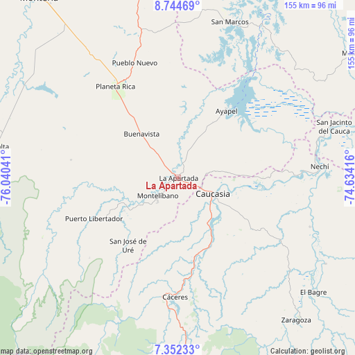
La Apartada GPS coordinates[2]
8° 2' 56.796" North, 75° 20' 14.208" West
| Map corner | latitude | longitude |
|---|---|---|
| Upper-left | 8.74469°, | -76.04041° |
| Center: | 8.04911°, | -75.33728° |
| Lower-right: | 7.35233°, | -74.63416° |
| Map W x H: | 154.8×154.8 km | = 96.2×96.2mi |
| max Lat: | 13.38166° ⇑18.9% North |
| La Apartada: | 8.04911° |
| min Lat: | ⇓81.1% South -4.21528° |
| min Long | La Apartada | max Long |
| -81.70636° | -75.33728° | -67.06996° |
| W 37.1%⇐ | ⇒62.9% E |
Elevation
Elevation of La Apartada is 66 m = 217 ft, and this is 1083.3 m = 3554 ft below average elevation for this country.
| Max E: |
3342 m = 10965 ft | 84.5% |
| Avg. | 1149.3 m = 3771 ft | |
| La Apartada | 66 m = 217 ft | |
Min E: |
1 m = 3 ft | 15.5% |
See also: Colombia elevation on elevation.city.
Geographical zone
La Apartada is located in North Torrid zone (between Equator and Tropic of Cancer). Distance of Equator is 895 km =556.1 mi to South.| Distance of | km | miles | from La Apartada |
|---|---|---|---|
| North Pole | 9112.1 | 5662 | to North |
| Arctic Circle | 6506.2 | 4042.8 | to North |
| Tropic Cancer | 1710.9 | 1063.1 | to North |
| Equator | 895 | 556.1 | to South |


Nearby cities:
15 places around La Apartada: (largest is in red/bold)
• Ayapel
36.6 km =22.7 mi,  36°
36°
• Buenavista
25 km =15.5 mi,  320°
320°
• Caucasia
17.3 km =10.7 mi,  113°
113°
• Cáceres
52.1 km =32.4 mi,  181°
181°
• Montelíbano
12 km =7.5 mi,  229°
229°
• Nechí
62 km =38.5 mi,  85°
85°
• Planeta Rica
48.7 km =30.3 mi,  325°
325°
• Pueblo Nuevo
46.9 km =29.1 mi,  62°
62°
• Pueblo Nuevo
53.7 km =33.4 mi,  339°
339°
• Puerto Libertador
40.7 km =25.3 mi,  244°
244°
• San Carlos
68.4 km =42.5 mi, 114°
• San Jacinto del Cauca
71.4 km =44.4 mi,  71°
71°
• San José de Uré
36.4 km =22.6 mi,  216°
216°
• San Marcos
71.7 km =44.6 mi,  18°
18°
• Tarazá
52.2 km =32.4 mi,  187°
187°
Sources, notices
• [Note1] Compared only with cities in Colombia existing in our database
• [Src1] Map data: © OpenStreetMap contributors (CC-BY-SA)
• [Src2] Other city data from geonames.org with taken over terms of usage.
• [Src3] Geographical zone / Annual Mean Temperature by Robert A. Rohde @ Wikipedia
