Ayapel geodata
Ayapel (Córdoba) is a seat of a second-order administrative division; located in Colombia in America/Bogota (GMT-5) time zone. With population of 22,602 people, there are 161 cities with bigger population in this country. Compared to other cities in Colombia, 82.7% of cities are located further ↓South; 57.4% of cities are located further →East and 91.2% of cities have higher elevation than Ayapel. Note1


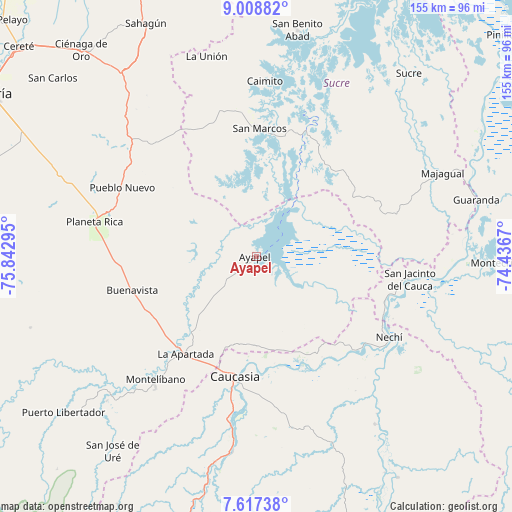
Ayapel GPS coordinates[2]
8° 18' 49.392" North, 75° 8' 23.352" West
| Map corner | latitude | longitude |
|---|---|---|
| Upper-left | 9.00882°, | -75.84295° |
| Center: | 8.31372°, | -75.13982° |
| Lower-right: | 7.61738°, | -74.4367° |
| Map W x H: | 154.7×154.7 km | = 96.1×96.1mi |
| max Lat: | 13.38166° ⇑17.3% North |
| Ayapel: | 8.31372° |
| min Lat: | ⇓82.7% South -4.21528° |
| min Long | Ayapel | max Long |
| -81.70636° | -75.13982° | -67.06996° |
| W 42.6%⇐ | ⇒57.4% E |
Elevation
Elevation of Ayapel is 25 m = 82 ft, and this is 1124.3 m = 3689 ft below average elevation for this country.
| Max E: |
3342 m = 10965 ft | 91.2% |
| Avg. | 1149.3 m = 3771 ft | |
| Ayapel | 25 m = 82 ft | |
Min E: |
1 m = 3 ft | 8.8% |
See also: Colombia elevation on elevation.city.
Geographical zone
Ayapel is located in North Torrid zone (between Equator and Tropic of Cancer). Distance of Equator is 924.4 km =574.4 mi to South.| Distance of | km | miles | from Ayapel |
|---|---|---|---|
| North Pole | 9082.7 | 5643.7 | to North |
| Arctic Circle | 6476.8 | 4024.5 | to North |
| Tropic Cancer | 1681.5 | 1044.8 | to North |
| Equator | 924.4 | 574.4 | to South |


Nearby cities:
15 places around Ayapel: (largest is in red/bold)
• Buenavista
39 km =24.2 mi,  254°
254°
• Caimito
53 km =32.9 mi,  2°
2°
• Caucasia
36.9 km =22.9 mi,  189°
189°
• Guaranda
68.6 km =42.6 mi,  75°
75°
• La Apartada
36.6 km =22.7 mi,  216°
216°
• La Unión
61.5 km =38.2 mi,  345°
345°
• Majagual
61.6 km =38.3 mi,  65°
65°
• Montelíbano
48.3 km =30 mi, 219°
• Nechí
46.9 km =29.1 mi,  121°
121°
• Planeta Rica
50.2 km =31.2 mi,  282°
282°
• Pueblo Nuevo
21.6 km =13.4 mi,  111°
111°
• Pueblo Nuevo
45.5 km =28.3 mi,  297°
297°
• San Benito Abad
69.5 km =43.2 mi,  10°
10°
• San Jacinto del Cauca
46.7 km =29 mi,  98°
98°
• San Marcos
38.5 km =23.9 mi, 1°
Sources, notices
• [Note1] Compared only with cities in Colombia existing in our database
• [Src1] Map data: © OpenStreetMap contributors (CC-BY-SA)
• [Src2] Other city data from geonames.org with taken over terms of usage.
• [Src3] Geographical zone / Annual Mean Temperature by Robert A. Rohde @ Wikipedia
