Pijao geodata
Pijao (Quindío) is a seat of a second-order administrative division; located in Colombia in America/Bogota (GMT-5) time zone. With population of 5,668 people, there are 465 cities with bigger population in this country. Compared to other cities in Colombia, 74.1% of cities are located further ↑North; 72.4% of cities are located further →East and 79.3% of cities have lower elevation than Pijao. Note1


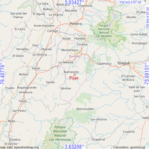
Pijao GPS coordinates[2]
4° 20' 0.6" North, 75° 42' 16.668" West
| Map corner | latitude | longitude |
|---|---|---|
| Upper-left | 5.03427°, | -76.40776° |
| Center: | 4.3335°, | -75.70463° |
| Lower-right: | 3.63208°, | -75.00151° |
| Map W x H: | 155.9×155.9 km | = 96.9×96.9mi |
| max Lat: | 13.38166° ⇑74.1% North |
| Pijao: | 4.3335° |
| min Lat: | ⇓25.9% South -4.21528° |
| min Long | Pijao | max Long |
| -81.70636° | -75.70463° | -67.06996° |
| W 27.6%⇐ | ⇒72.4% E |
Elevation
Elevation of Pijao is 2010 m = 6594 ft, and this is 860.7 m = 2824 ft above average elevation for this country.
| Max E: |
3342 m = 10965 ft | 20.7% |
| Pijao | 2010 m 6594 ft | |
| Avg. | 1149.3 m = 3771 ft | |
Min E: |
1 m = 3 ft | 79.3% |
See also: Colombia elevation on elevation.city.
Geographical zone
Pijao is located in North Torrid zone (between Equator and Tropic of Cancer). Distance of Equator is 481.8 km =299.4 mi to South.| Distance of | km | miles | from Pijao |
|---|---|---|---|
| North Pole | 9525.2 | 5918.7 | to North |
| Arctic Circle | 6919.3 | 4299.5 | to North |
| Tropic Cancer | 2124.1 | 1319.9 | to North |
| Equator | 481.8 | 299.4 | to South |


Nearby cities:
15 places around Pijao: (largest is in red/bold)
• Anaime
29.6 km =18.4 mi,  76°
76°
• Armenia
22.4 km =13.9 mi,  6°
6°
• Buenavista
4.8 km =3 mi,  307°
307°
• Caicedonia
13.5 km =8.4 mi,  269°
269°
• Cajamarca
32.9 km =20.4 mi,  68°
68°
• Calarcá
22.9 km =14.2 mi,  17°
17°
• Circasia
32.6 km =20.3 mi, 13°
• Córdoba
6.7 km =4.2 mi, 16°
• Génova
7.1 km =4.4 mi,  254°
254°
• Génova
16.8 km =10.4 mi,  213°
213°
• La Tebaida
16.1 km =10 mi,  325°
325°
• Montenegro
26.4 km =16.4 mi,  348°
348°
• Quimbaya
32.8 km =20.4 mi, 348°
• Salento
36.9 km =22.9 mi, 23°
• Sevilla
26.2 km =16.3 mi, 252°
Sources, notices
• [Note1] Compared only with cities in Colombia existing in our database
• [Src1] Map data: © OpenStreetMap contributors (CC-BY-SA)
• [Src2] Other city data from geonames.org with taken over terms of usage.
• [Src3] Geographical zone / Annual Mean Temperature by Robert A. Rohde @ Wikipedia
