Buenavista geodata
Buenavista (Quindío) is a seat of a second-order administrative division; located in Colombia in America/Bogota (GMT-5) time zone. With population of 2,084 people, there are 789 cities with bigger population in this country. Compared to other cities in Colombia, 73.5% of cities are located further ↑North; 73.5% of cities are located further →East and 61.4% of cities have lower elevation than Buenavista. Note1


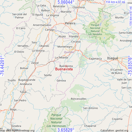
Buenavista GPS coordinates[2]
4° 21' 34.884" North, 75° 44' 19.968" West
| Map corner | latitude | longitude |
|---|---|---|
| Upper-left | 5.06044°, | -76.44201° |
| Center: | 4.35969°, | -75.73888° |
| Lower-right: | 3.65829°, | -75.03576° |
| Map W x H: | 155.9×155.9 km | = 96.9×96.9mi |
| max Lat: | 13.38166° ⇑73.5% North |
| Buenavista: | 4.35969° |
| min Lat: | ⇓26.5% South -4.21528° |
| min Long | Buenavista | max Long |
| -81.70636° | -75.73888° | -67.06996° |
| W 26.5%⇐ | ⇒73.5% E |
Elevation
Elevation of Buenavista is 1514 m = 4967 ft, and this is 364.7 m = 1197 ft above average elevation for this country.
| Max E: |
3342 m = 10965 ft | 38.6% |
| Buenavista | 1514 m 4967 ft | |
| Avg. | 1149.3 m = 3771 ft | |
Min E: |
1 m = 3 ft | 61.4% |
See also: Colombia elevation on elevation.city.
Geographical zone
Buenavista is located in North Torrid zone (between Equator and Tropic of Cancer). Distance of Equator is 484.8 km =301.2 mi to South.| Distance of | km | miles | from Buenavista |
|---|---|---|---|
| North Pole | 9522.3 | 5916.9 | to North |
| Arctic Circle | 6916.4 | 4297.7 | to North |
| Tropic Cancer | 2121.2 | 1318.1 | to North |
| Equator | 484.8 | 301.2 | to South |


Nearby cities:
15 places around Buenavista: (largest is in red/bold)
• Alcalá
35.4 km =22 mi,  352°
352°
• Anaime
32.8 km =20.4 mi,  82°
82°
• Armenia
20.4 km =12.7 mi,  18°
18°
• Caicedonia
10.2 km =6.3 mi,  252°
252°
• Calarcá
21.8 km =13.5 mi,  29°
29°
• Circasia
31 km =19.3 mi, 21°
• Córdoba
6.7 km =4.2 mi,  58°
58°
• Génova
5.7 km =3.5 mi,  212°
212°
• Génova
17.8 km =11.1 mi,  198°
198°
• La Tebaida
11.7 km =7.3 mi,  332°
332°
• Montenegro
23 km =14.3 mi,  356°
356°
• Obando
35.4 km =22 mi,  312°
312°
• Pijao
4.8 km =3 mi,  127°
127°
• Quimbaya
29.4 km =18.3 mi, 354°
• Sevilla
23.8 km =14.8 mi,  243°
243°
Sources, notices
• [Note1] Compared only with cities in Colombia existing in our database
• [Src1] Map data: © OpenStreetMap contributors (CC-BY-SA)
• [Src2] Other city data from geonames.org with taken over terms of usage.
• [Src3] Geographical zone / Annual Mean Temperature by Robert A. Rohde @ Wikipedia
