Iscuandé geodata
Iscuandé (Nariño) is a seat of a second-order administrative division; located in Colombia in America/Bogota (GMT-5) time zone. With population of 4,875 people, there are 518 cities with bigger population in this country. Compared to other cities in Colombia, 87.4% of cities are located further ↑North; 98.9% of cities are located further →East and 98.9% of cities have higher elevation than Iscuandé. Note1


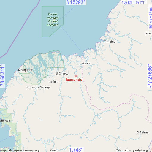
Iscuandé GPS coordinates[2]
2° 27' 2.34" North, 77° 58' 47.928" West
| Map corner | latitude | longitude |
|---|---|---|
| Upper-left | 3.15293°, | -78.68311° |
| Center: | 2.45065°, | -77.97998° |
| Lower-right: | 1.748°, | -77.27686° |
| Map W x H: | 156.2×156.2 km | = 97.1×97.1mi |
| max Lat: | 13.38166° ⇑87.4% North |
| Iscuandé: | 2.45065° |
| min Lat: | ⇓12.6% South -4.21528° |
| min Long | Iscuandé | max Long |
| -81.70636° | -77.97998° | -67.06996° |
| W 1.1%⇐ | ⇒98.9% E |
Elevation
Elevation of Iscuandé is 5 m = 16 ft, and this is 1144.3 m = 3754 ft below average elevation for this country.
| Max E: |
3342 m = 10965 ft | 98.9% |
| Avg. | 1149.3 m = 3771 ft | |
| Iscuandé | 5 m = 16 ft | |
Min E: |
1 m = 3 ft | 1.1% |
See also: Colombia elevation on elevation.city.
Geographical zone
Iscuandé is located in North Torrid zone (between Equator and Tropic of Cancer). Distance of Equator is 272.5 km =169.3 mi to South.| Distance of | km | miles | from Iscuandé |
|---|---|---|---|
| North Pole | 9734.6 | 6048.8 | to North |
| Arctic Circle | 7128.7 | 4429.6 | to North |
| Tropic Cancer | 2333.4 | 1449.9 | to North |
| Equator | 272.5 | 169.3 | to South |


Nearby cities:
15 places around Iscuandé: (largest is in red/bold)
• Argelia
84.1 km =52.3 mi,  104°
104°
• Balboa
96.2 km =59.8 mi,  118°
118°
• Barbacoas
88.4 km =54.9 mi,  191°
191°
• Bocas de Satinga
40.1 km =24.9 mi,  253°
253°
• Cumbitara
99.8 km =62 mi,  153°
153°
• El Charco
14.8 km =9.2 mi,  282°
282°
• Guapí
17 km =10.6 mi,  38°
38°
• La Tola
23.9 km =14.9 mi,  256°
256°
• Leiva
94.3 km =58.6 mi,  127°
127°
• López
92.4 km =57.4 mi,  61°
61°
• Mosquera
52.7 km =32.7 mi, 277°
• Payán
79.4 km =49.3 mi,  196°
196°
• Salahonda
88.1 km =54.7 mi,  238°
238°
• San José
88.9 km =55.2 mi, 199°
• Timbiquí
50 km =31.1 mi, 44°
Sources, notices
• [Note1] Compared only with cities in Colombia existing in our database
• [Src1] Map data: © OpenStreetMap contributors (CC-BY-SA)
• [Src2] Other city data from geonames.org with taken over terms of usage.
• [Src3] Geographical zone / Annual Mean Temperature by Robert A. Rohde @ Wikipedia
