Páramo geodata
Páramo (Santander) is a seat of a second-order administrative division; located in Colombia in America/Bogota (GMT-5) time zone. With population of 843 people, there are 971 cities with bigger population in this country. Compared to other cities in Colombia, 66.7% of cities are located further ↓South; 83.4% of cities are located further ←West and 57.7% of cities have lower elevation than Páramo. Note1


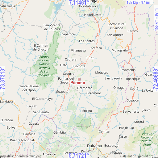
Páramo GPS coordinates[2]
6° 24' 59.004" North, 73° 10' 12" West
| Map corner | latitude | longitude |
|---|---|---|
| Upper-left | 7.11461°, | -73.87313° |
| Center: | 6.41639°, | -73.17° |
| Lower-right: | 5.71721°, | -72.46688° |
| Map W x H: | 155.4×155.4 km | = 96.6×96.6mi |
| max Lat: | 13.38166° ⇑33.3% North |
| Páramo: | 6.41639° |
| min Lat: | ⇓66.7% South -4.21528° |
| min Long | Páramo | max Long |
| -81.70636° | -73.17° | -67.06996° |
| W 83.4%⇐ | ⇒16.6% E |
Elevation
Elevation of Páramo is 1406 m = 4613 ft, and this is 256.7 m = 842 ft above average elevation for this country.
| Max E: |
3342 m = 10965 ft | 42.3% |
| Páramo | 1406 m 4613 ft | |
| Avg. | 1149.3 m = 3771 ft | |
Min E: |
1 m = 3 ft | 57.7% |
See also: Colombia elevation on elevation.city.
Geographical zone
Páramo is located in North Torrid zone (between Equator and Tropic of Cancer). Distance of Equator is 713.4 km =443.3 mi to South.| Distance of | km | miles | from Páramo |
|---|---|---|---|
| North Pole | 9293.6 | 5774.8 | to North |
| Arctic Circle | 6687.7 | 4155.5 | to North |
| Tropic Cancer | 1892.5 | 1175.9 | to North |
| Equator | 713.4 | 443.3 | to South |


Nearby cities:
15 places around Páramo: (largest is in red/bold)
• Cabrera
21.4 km =13.3 mi,  336°
336°
• Charalá
14.7 km =9.1 mi,  170°
170°
• Confines
10.3 km =6.4 mi,  229°
229°
• Coromoro
19.7 km =12.2 mi,  133°
133°
• Guapotá
20.5 km =12.7 mi, 234°
• Hato
20.8 km =12.9 mi,  312°
312°
• Ocamonte
10 km =6.2 mi,  148°
148°
• Oiba
22.1 km =13.7 mi,  219°
219°
• Palmar
19.1 km =11.9 mi, 314°
• Palmas del Socorro
13.1 km =8.1 mi,  265°
265°
• Pinchote
12.9 km =8 mi,  358°
358°
• San Gil
16.3 km =10.1 mi,  13°
13°
• Simacota
18.7 km =11.6 mi,  279°
279°
• Socorro
11.5 km =7.1 mi,  300°
300°
• Valle de San José
4.5 km =2.8 mi,  40°
40°
Sources, notices
• [Note1] Compared only with cities in Colombia existing in our database
• [Src1] Map data: © OpenStreetMap contributors (CC-BY-SA)
• [Src2] Other city data from geonames.org with taken over terms of usage.
• [Src3] Geographical zone / Annual Mean Temperature by Robert A. Rohde @ Wikipedia
