Cabrera geodata
Cabrera (Santander) is a seat of a second-order administrative division; located in Colombia in America/Bogota (GMT-5) time zone. With population of 363 people, there are 1038 cities with bigger population in this country. Compared to other cities in Colombia, 69.8% of cities are located further ↓South; 81.7% of cities are located further ←West and 51.6% of cities have lower elevation than Cabrera. Note1


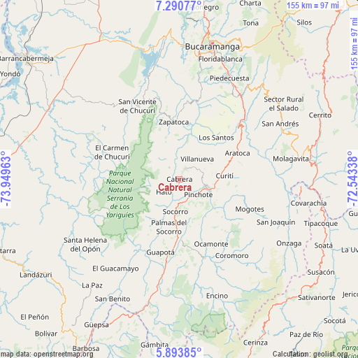
Cabrera GPS coordinates[2]
6° 35' 34.08" North, 73° 14' 47.4" West
| Map corner | latitude | longitude |
|---|---|---|
| Upper-left | 7.29077°, | -73.94963° |
| Center: | 6.5928°, | -73.2465° |
| Lower-right: | 5.89385°, | -72.54338° |
| Map W x H: | 155.3×155.3 km | = 96.5×96.5mi |
| max Lat: | 13.38166° ⇑30.2% North |
| Cabrera: | 6.5928° |
| min Lat: | ⇓69.8% South -4.21528° |
| min Long | Cabrera | max Long |
| -81.70636° | -73.2465° | -67.06996° |
| W 81.7%⇐ | ⇒18.3% E |
Elevation
Elevation of Cabrera is 1190 m = 3904 ft, and this is 40.7 m = 134 ft above average elevation for this country.
| Max E: |
3342 m = 10965 ft | 48.4% |
| Cabrera | 1190 m 3904 ft | |
| Avg. | 1149.3 m = 3771 ft | |
Min E: |
1 m = 3 ft | 51.6% |
See also: Colombia elevation on elevation.city.
Geographical zone
Cabrera is located in North Torrid zone (between Equator and Tropic of Cancer). Distance of Equator is 733.1 km =455.5 mi to South.| Distance of | km | miles | from Cabrera |
|---|---|---|---|
| North Pole | 9274 | 5762.6 | to North |
| Arctic Circle | 6668.1 | 4143.4 | to North |
| Tropic Cancer | 1872.9 | 1163.8 | to North |
| Equator | 733.1 | 455.5 | to South |


Nearby cities:
15 places around Cabrera: (largest is in red/bold)
• Barichara
5.4 km =3.4 mi,  28°
28°
• Curití
19.8 km =12.3 mi,  86°
86°
• Galán
6.8 km =4.2 mi,  316°
316°
• Hato
8.8 km =5.5 mi,  230°
230°
• Jordán
22.8 km =14.2 mi,  46°
46°
• Los Santos
23.8 km =14.8 mi,  41°
41°
• Palmar
7.9 km =4.9 mi,  219°
219°
• Palmas del Socorro
21.1 km =13.1 mi,  192°
192°
• Pinchote
10.5 km =6.5 mi,  129°
129°
• Páramo
21.4 km =13.3 mi,  156°
156°
• San Gil
12.7 km =7.9 mi,  106°
106°
• Simacota
19.4 km =12.1 mi,  210°
210°
• Socorro
13.9 km =8.6 mi, 186°
• Valle de San José
19.8 km =12.3 mi,  144°
144°
• Villanueva
11.9 km =7.4 mi, 42°
Sources, notices
• [Note1] Compared only with cities in Colombia existing in our database
• [Src1] Map data: © OpenStreetMap contributors (CC-BY-SA)
• [Src2] Other city data from geonames.org with taken over terms of usage.
• [Src3] Geographical zone / Annual Mean Temperature by Robert A. Rohde @ Wikipedia
