San Gil geodata
San Gil (Santander) is a populated place; located in Colombia in America/Bogota (GMT-5) time zone. With population of 33,592 people, there are 111 cities with bigger population in this country. Compared to other cities in Colombia, 69.5% of cities are located further ↓South; 84.2% of cities are located further ←West and 50.9% of cities have lower elevation than San Gil. Note1


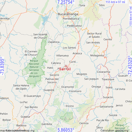
San Gil GPS coordinates[2]
6° 33' 34.272" North, 73° 8' 10.932" West
| Map corner | latitude | longitude |
|---|---|---|
| Upper-left | 7.25754°, | -73.8395° |
| Center: | 6.55952°, | -73.13637° |
| Lower-right: | 5.86053°, | -72.43325° |
| Map W x H: | 155.3×155.3 km | = 96.5×96.5mi |
| max Lat: | 13.38166° ⇑30.5% North |
| San Gil: | 6.55952° |
| min Lat: | ⇓69.5% South -4.21528° |
| min Long | San Gil | max Long |
| -81.70636° | -73.13637° | -67.06996° |
| W 84.2%⇐ | ⇒15.8% E |
Elevation
Elevation of San Gil is 1152 m = 3780 ft, and this is 2.7 m = 9 ft above average elevation for this country.
| Max E: |
3342 m = 10965 ft | 49.1% |
| San Gil | 1152 m 3780 ft | |
| Avg. | 1149.3 m = 3771 ft | |
Min E: |
1 m = 3 ft | 50.9% |
See also: Colombia elevation on elevation.city.
Geographical zone
San Gil is located in North Torrid zone (between Equator and Tropic of Cancer). Distance of Equator is 729.4 km =453.2 mi to South.| Distance of | km | miles | from San Gil |
|---|---|---|---|
| North Pole | 9277.7 | 5764.9 | to North |
| Arctic Circle | 6671.8 | 4145.7 | to North |
| Tropic Cancer | 1876.6 | 1166.1 | to North |
| Equator | 729.4 | 453.2 | to South |


Nearby cities:
15 places around San Gil: (largest is in red/bold)
• Aratoca
19.8 km =12.3 mi,  40°
40°
• Barichara
12.8 km =8 mi,  311°
311°
• Cabrera
12.7 km =7.9 mi,  286°
286°
• Curití
9.1 km =5.7 mi,  56°
56°
• Galán
19 km =11.8 mi,  297°
297°
• Hato
19.1 km =11.9 mi,  264°
264°
• Jordán
19.8 km =12.3 mi,  13°
13°
• Los Santos
21.8 km =13.5 mi, 9°
• Mogotes
20.6 km =12.8 mi,  116°
116°
• Palmar
17.4 km =10.8 mi, 261°
• Pinchote
5.1 km =3.2 mi,  233°
233°
• Páramo
16.3 km =10.1 mi,  193°
193°
• Socorro
17 km =10.6 mi, 233°
• Valle de San José
12.5 km =7.8 mi,  183°
183°
• Villanueva
13.2 km =8.2 mi,  341°
341°
Sources, notices
• [Note1] Compared only with cities in Colombia existing in our database
• [Src1] Map data: © OpenStreetMap contributors (CC-BY-SA)
• [Src2] Other city data from geonames.org with taken over terms of usage.
• [Src3] Geographical zone / Annual Mean Temperature by Robert A. Rohde @ Wikipedia
