Socorro geodata
Socorro (Santander) is a seat of a second-order administrative division; located in Colombia in America/Bogota (GMT-5) time zone. With population of 17,752 people, there are 198 cities with bigger population in this country. Compared to other cities in Colombia, 67.8% of cities are located further ↓South; 81.4% of cities are located further ←West and 52.8% of cities have lower elevation than Socorro. Note1


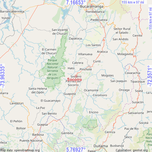
Socorro GPS coordinates[2]
6° 28' 6.168" North, 73° 15' 36.792" West
| Map corner | latitude | longitude |
|---|---|---|
| Upper-left | 7.16653°, | -73.96335° |
| Center: | 6.46838°, | -73.26022° |
| Lower-right: | 5.76927°, | -72.5571° |
| Map W x H: | 155.4×155.4 km | = 96.6×96.6mi |
| max Lat: | 13.38166° ⇑32.2% North |
| Socorro: | 6.46838° |
| min Lat: | ⇓67.8% South -4.21528° |
| min Long | Socorro | max Long |
| -81.70636° | -73.26022° | -67.06996° |
| W 81.4%⇐ | ⇒18.6% E |
Elevation
Elevation of Socorro is 1234 m = 4049 ft, and this is 84.7 m = 278 ft above average elevation for this country.
| Max E: |
3342 m = 10965 ft | 47.2% |
| Socorro | 1234 m 4049 ft | |
| Avg. | 1149.3 m = 3771 ft | |
Min E: |
1 m = 3 ft | 52.8% |
See also: Colombia elevation on elevation.city.
Geographical zone
Socorro is located in North Torrid zone (between Equator and Tropic of Cancer). Distance of Equator is 719.2 km =446.9 mi to South.| Distance of | km | miles | from Socorro |
|---|---|---|---|
| North Pole | 9287.8 | 5771.2 | to North |
| Arctic Circle | 6682 | 4152 | to North |
| Tropic Cancer | 1886.7 | 1172.3 | to North |
| Equator | 719.2 | 446.9 | to South |


Nearby cities:
15 places around Socorro: (largest is in red/bold)
• Barichara
19.1 km =11.9 mi,  12°
12°
• Cabrera
13.9 km =8.6 mi, 6°
• Chima
18.7 km =11.6 mi,  222°
222°
• Confines
12.6 km =7.8 mi,  170°
170°
• Galán
19.1 km =11.9 mi,  350°
350°
• Guapotá
19 km =11.8 mi,  200°
200°
• Hato
9.9 km =6.2 mi,  327°
327°
• Ocamonte
20.9 km =13 mi,  133°
133°
• Palmar
8.5 km =5.3 mi,  335°
335°
• Palmas del Socorro
7.4 km =4.6 mi, 204°
• Pinchote
12 km =7.5 mi,  53°
53°
• Páramo
11.5 km =7.1 mi,  120°
120°
• San Gil
17 km =10.6 mi, 53°
• Simacota
8.9 km =5.5 mi,  251°
251°
• Valle de San José
13.1 km =8.1 mi,  100°
100°
Sources, notices
• [Note1] Compared only with cities in Colombia existing in our database
• [Src1] Map data: © OpenStreetMap contributors (CC-BY-SA)
• [Src2] Other city data from geonames.org with taken over terms of usage.
• [Src3] Geographical zone / Annual Mean Temperature by Robert A. Rohde @ Wikipedia
