Palmar geodata
Palmar (Santander) is a seat of a second-order administrative division; located in Colombia in America/Bogota (GMT-5) time zone. With population of 360 people, there are 1039 cities with bigger population in this country. Compared to other cities in Colombia, 68.8% of cities are located further ↓South; 80.7% of cities are located further ←West and 57.7% of cities have higher elevation than Palmar. Note1


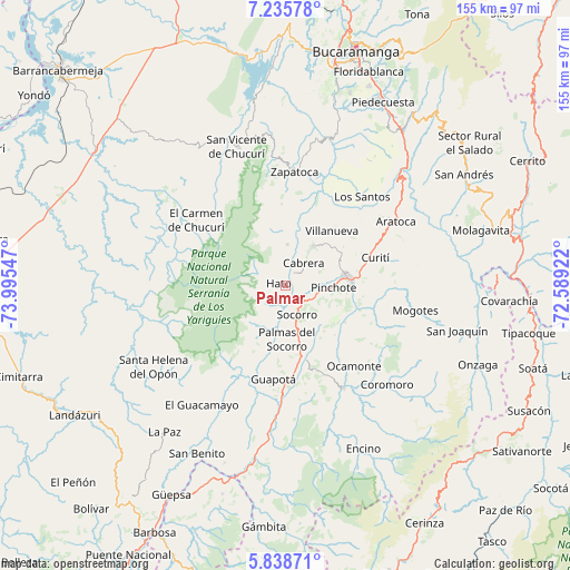
Palmar GPS coordinates[2]
6° 32' 15.828" North, 73° 17' 32.424" West
| Map corner | latitude | longitude |
|---|---|---|
| Upper-left | 7.23578°, | -73.99547° |
| Center: | 6.53773°, | -73.29234° |
| Lower-right: | 5.83871°, | -72.58922° |
| Map W x H: | 155.3×155.3 km | = 96.5×96.5mi |
| max Lat: | 13.38166° ⇑31.2% North |
| Palmar: | 6.53773° |
| min Lat: | ⇓68.8% South -4.21528° |
| min Long | Palmar | max Long |
| -81.70636° | -73.29234° | -67.06996° |
| W 80.7%⇐ | ⇒19.3% E |
Elevation
Elevation of Palmar is 907 m = 2976 ft, and this is 242.3 m = 795 ft below average elevation for this country.
| Max E: |
3342 m = 10965 ft | 57.7% |
| Avg. | 1149.3 m = 3771 ft | |
| Palmar | 907 m = 2976 ft | |
Min E: |
1 m = 3 ft | 42.3% |
See also: Colombia elevation on elevation.city.
Geographical zone
Palmar is located in North Torrid zone (between Equator and Tropic of Cancer). Distance of Equator is 726.9 km =451.7 mi to South.| Distance of | km | miles | from Palmar |
|---|---|---|---|
| North Pole | 9280.1 | 5766.4 | to North |
| Arctic Circle | 6674.2 | 4147.2 | to North |
| Tropic Cancer | 1879 | 1167.6 | to North |
| Equator | 726.9 | 451.7 | to South |


Nearby cities:
15 places around Palmar: (largest is in red/bold)
• Barichara
13.3 km =8.3 mi,  35°
35°
• Cabrera
7.9 km =4.9 mi, 39°
• Chima
23.3 km =14.5 mi,  202°
202°
• Confines
21 km =13 mi,  164°
164°
• Galán
11.1 km =6.9 mi,  2°
2°
• Guapotá
25.7 km =16 mi,  186°
186°
• Hato
1.9 km =1.2 mi,  288°
288°
• Palmas del Socorro
14.5 km =9 mi,  178°
178°
• Pinchote
13.2 km =8.2 mi,  92°
92°
• Páramo
19.1 km =11.9 mi,  134°
134°
• San Gil
17.4 km =10.8 mi,  81°
81°
• Simacota
11.6 km =7.2 mi,  205°
205°
• Socorro
8.5 km =5.3 mi, 155°
• Valle de San José
19.3 km =12 mi,  121°
121°
• Villanueva
19.8 km =12.3 mi, 41°
Sources, notices
• [Note1] Compared only with cities in Colombia existing in our database
• [Src1] Map data: © OpenStreetMap contributors (CC-BY-SA)
• [Src2] Other city data from geonames.org with taken over terms of usage.
• [Src3] Geographical zone / Annual Mean Temperature by Robert A. Rohde @ Wikipedia
