Muzo geodata
Muzo (Boyacá) is a seat of a second-order administrative division; located in Colombia in America/Bogota (GMT-5) time zone. With population of 7,977 people, there are 369 cities with bigger population in this country. Compared to other cities in Colombia, 50.3% of cities are located further ↓South; 63% of cities are located further ←West and 59.7% of cities have higher elevation than Muzo. Note1


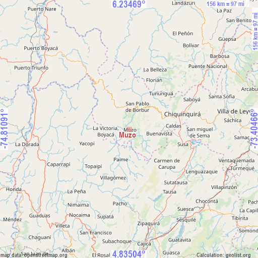
Muzo GPS coordinates[2]
5° 32' 7.008" North, 74° 6' 28.008" West
| Map corner | latitude | longitude |
|---|---|---|
| Upper-left | 6.23469°, | -74.81091° |
| Center: | 5.53528°, | -74.10778° |
| Lower-right: | 4.83504°, | -73.40466° |
| Map W x H: | 155.6×155.6 km | = 96.7×96.7mi |
| max Lat: | 13.38166° ⇑49.7% North |
| Muzo: | 5.53528° |
| min Lat: | ⇓50.3% South -4.21528° |
| min Long | Muzo | max Long |
| -81.70636° | -74.10778° | -67.06996° |
| W 63%⇐ | ⇒37% E |
Elevation
Elevation of Muzo is 770 m = 2526 ft, and this is 379.3 m = 1244 ft below average elevation for this country.
| Max E: |
3342 m = 10965 ft | 59.7% |
| Avg. | 1149.3 m = 3771 ft | |
| Muzo | 770 m = 2526 ft | |
Min E: |
1 m = 3 ft | 40.3% |
See also: Colombia elevation on elevation.city.
Geographical zone
Muzo is located in North Torrid zone (between Equator and Tropic of Cancer). Distance of Equator is 615.5 km =382.5 mi to South.| Distance of | km | miles | from Muzo |
|---|---|---|---|
| North Pole | 9391.6 | 5835.7 | to North |
| Arctic Circle | 6785.7 | 4216.4 | to North |
| Tropic Cancer | 1990.5 | 1236.8 | to North |
| Equator | 615.5 | 382.5 | to South |


Nearby cities:
15 places around Muzo: (largest is in red/bold)
• Briceño
27 km =16.8 mi,  51°
51°
• Buenavista
17.7 km =11 mi,  97°
97°
• Caldas
26.9 km =16.7 mi,  85°
85°
• Coper
9.6 km =6 mi,  132°
132°
• La Victoria
14.2 km =8.8 mi,  265°
265°
• Maripí
11.1 km =6.9 mi,  80°
80°
• Otanche
15.8 km =9.8 mi,  328°
328°
• Paime
19 km =11.8 mi,  195°
195°
• Pauna
19.5 km =12.1 mi, 45°
• Quípama
7.9 km =4.9 mi,  257°
257°
• San Cayetano
23.9 km =14.9 mi,  157°
157°
• San Cayetano
26.3 km =16.3 mi,  170°
170°
• San Pablo de Borbur
13.6 km =8.5 mi,  17°
17°
• Tununguá
28.4 km =17.6 mi,  40°
40°
• Yacopí
26.9 km =16.7 mi,  251°
251°
Sources, notices
• [Note1] Compared only with cities in Colombia existing in our database
• [Src1] Map data: © OpenStreetMap contributors (CC-BY-SA)
• [Src2] Other city data from geonames.org with taken over terms of usage.
• [Src3] Geographical zone / Annual Mean Temperature by Robert A. Rohde @ Wikipedia
