Combita geodata
Combita (Boyacá) is a populated place; located in Colombia in America/Bogota (GMT-5) time zone. With population of 1,034 people, there are 943 cities with bigger population in this country. Compared to other cities in Colombia, 52.8% of cities are located further ↓South; 80.1% of cities are located further ←West and 96.7% of cities have lower elevation than Combita. Note1


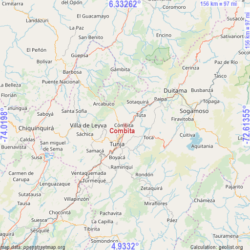
Combita GPS coordinates[2]
5° 37' 59.988" North, 73° 19' 0.012" West
| Map corner | latitude | longitude |
|---|---|---|
| Upper-left | 6.33262°, | -74.0198° |
| Center: | 5.63333°, | -73.31667° |
| Lower-right: | 4.9332°, | -72.61355° |
| Map W x H: | 155.6×155.6 km | = 96.7×96.7mi |
| max Lat: | 13.38166° ⇑47.2% North |
| Combita: | 5.63333° |
| min Lat: | ⇓52.8% South -4.21528° |
| min Long | Combita | max Long |
| -81.70636° | -73.31667° | -67.06996° |
| W 80.1%⇐ | ⇒19.9% E |
Elevation
Elevation of Combita is 2745 m = 9006 ft, and this is 1595.7 m = 5235 ft above average elevation for this country.
| Max E: |
3342 m = 10965 ft | 3.3% |
| Combita | 2745 m 9006 ft | |
| Avg. | 1149.3 m = 3771 ft | |
Min E: |
1 m = 3 ft | 96.7% |
See also: Colombia elevation on elevation.city.
Geographical zone
Combita is located in North Torrid zone (between Equator and Tropic of Cancer). Distance of Equator is 626.4 km =389.2 mi to South.| Distance of | km | miles | from Combita |
|---|---|---|---|
| North Pole | 9380.7 | 5828.9 | to North |
| Arctic Circle | 6774.8 | 4209.7 | to North |
| Tropic Cancer | 1979.6 | 1230.1 | to North |
| Equator | 626.4 | 389.2 | to South |


Nearby cities:
15 places around Combita: (largest is in red/bold)
• Arcabuco
18.9 km =11.7 mi,  315°
315°
• Chivatá
9.2 km =5.7 mi,  155°
155°
• Chíquiza
18.9 km =11.7 mi,  260°
260°
• Cucaita
18.2 km =11.3 mi,  236°
236°
• Cómbita
0.8 km =0.5 mi,  268°
268°
• La Capilla
19.3 km =12 mi,  294°
294°
• Motavita
8.4 km =5.2 mi,  221°
221°
• Oicatá
4.3 km =2.7 mi,  167°
167°
• Siachoque
15.6 km =9.7 mi,  149°
149°
• Sora
16.6 km =10.3 mi, 242°
• Soracá
14.9 km =9.3 mi,  186°
186°
• Sotaquirá
16.5 km =10.3 mi,  27°
27°
• Toca
16.6 km =10.3 mi,  117°
117°
• Tunja
12.3 km =7.6 mi,  207°
207°
• Tuta
11.7 km =7.3 mi,  57°
57°
Sources, notices
• [Note1] Compared only with cities in Colombia existing in our database
• [Src1] Map data: © OpenStreetMap contributors (CC-BY-SA)
• [Src2] Other city data from geonames.org with taken over terms of usage.
• [Src3] Geographical zone / Annual Mean Temperature by Robert A. Rohde @ Wikipedia
