Sotaquirá geodata
Sotaquirá (Boyacá) is a seat of a second-order administrative division; located in Colombia in America/Bogota (GMT-5) time zone. With population of 1,352 people, there are 894 cities with bigger population in this country. Compared to other cities in Colombia, 55.4% of cities are located further ↓South; 81.6% of cities are located further ←West and 95% of cities have lower elevation than Sotaquirá. Note1


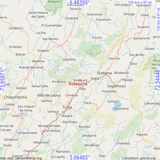
Sotaquirá GPS coordinates[2]
5° 45' 53.388" North, 73° 14' 51.288" West
| Map corner | latitude | longitude |
|---|---|---|
| Upper-left | 6.46395°, | -73.95071° |
| Center: | 5.76483°, | -73.24758° |
| Lower-right: | 5.06485°, | -72.54446° |
| Map W x H: | 155.6×155.6 km | = 96.7×96.7mi |
| max Lat: | 13.38166° ⇑44.6% North |
| Sotaquirá: | 5.76483° |
| min Lat: | ⇓55.4% South -4.21528° |
| min Long | Sotaquirá | max Long |
| -81.70636° | -73.24758° | -67.06996° |
| W 81.6%⇐ | ⇒18.4% E |
Elevation
Elevation of Sotaquirá is 2677 m = 8783 ft, and this is 1527.7 m = 5012 ft above average elevation for this country.
| Max E: |
3342 m = 10965 ft | 5% |
| Sotaquirá | 2677 m 8783 ft | |
| Avg. | 1149.3 m = 3771 ft | |
Min E: |
1 m = 3 ft | 95% |
See also: Colombia elevation on elevation.city.
Geographical zone
Sotaquirá is located in North Torrid zone (between Equator and Tropic of Cancer). Distance of Equator is 641 km =398.3 mi to South.| Distance of | km | miles | from Sotaquirá |
|---|---|---|---|
| North Pole | 9366.1 | 5819.8 | to North |
| Arctic Circle | 6760.2 | 4200.6 | to North |
| Tropic Cancer | 1964.9 | 1220.9 | to North |
| Equator | 641 | 398.3 | to South |


Nearby cities:
15 places around Sotaquirá: (largest is in red/bold)
• Arcabuco
21 km =13 mi,  266°
266°
• Chivatá
23.3 km =14.5 mi,  189°
189°
• Combita
16.5 km =10.3 mi,  207°
207°
• Cómbita
16.9 km =10.5 mi, 209°
• Duitama
24.5 km =15.2 mi,  74°
74°
• Gámbita
22.8 km =14.2 mi,  332°
332°
• La Capilla
26.1 km =16.2 mi,  255°
255°
• Motavita
24.8 km =15.4 mi, 212°
• Oicatá
20 km =12.4 mi,  199°
199°
• Paipa
14.5 km =9 mi,  83°
83°
• Siachoque
28.1 km =17.5 mi,  179°
179°
• Tibasosa
27.4 km =17 mi,  93°
93°
• Toca
23.4 km =14.5 mi,  162°
162°
• Tunja
28.8 km =17.9 mi, 207°
• Tuta
8.6 km =5.3 mi,  165°
165°
Sources, notices
• [Note1] Compared only with cities in Colombia existing in our database
• [Src1] Map data: © OpenStreetMap contributors (CC-BY-SA)
• [Src2] Other city data from geonames.org with taken over terms of usage.
• [Src3] Geographical zone / Annual Mean Temperature by Robert A. Rohde @ Wikipedia
