Patía geodata
Patía (Cauca) is a populated place; located in Colombia in America/Bogota (GMT-5) time zone. With population of 20,807 people, there are 170 cities with bigger population in this country. Compared to other cities in Colombia, 89.4% of cities are located further ↑North; 93% of cities are located further →East and 61.8% of cities have higher elevation than Patía. Note1


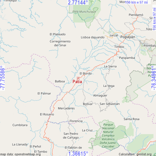
Patía GPS coordinates[2]
2° 4' 8.22" North, 77° 3' 9.828" West
| Map corner | latitude | longitude |
|---|---|---|
| Upper-left | 2.77144°, | -77.75586° |
| Center: | 2.06895°, | -77.05273° |
| Lower-right: | 1.36615°, | -76.34961° |
| Map W x H: | 156.3×156.3 km | = 97.1×97.1mi |
| max Lat: | 13.38166° ⇑89.4% North |
| Patía: | 2.06895° |
| min Lat: | ⇓10.6% South -4.21528° |
| min Long | Patía | max Long |
| -81.70636° | -77.05273° | -67.06996° |
| W 7%⇐ | ⇒93% E |
Elevation
Elevation of Patía is 619 m = 2031 ft, and this is 530.3 m = 1740 ft below average elevation for this country.
| Max E: |
3342 m = 10965 ft | 61.8% |
| Avg. | 1149.3 m = 3771 ft | |
| Patía | 619 m = 2031 ft | |
Min E: |
1 m = 3 ft | 38.2% |
See also: Colombia elevation on elevation.city.
Geographical zone
Patía is located in North Torrid zone (between Equator and Tropic of Cancer). Distance of Equator is 230 km =142.9 mi to South.| Distance of | km | miles | from Patía |
|---|---|---|---|
| North Pole | 9777 | 6075.1 | to North |
| Arctic Circle | 7171.1 | 4455.9 | to North |
| Tropic Cancer | 2375.9 | 1476.3 | to North |
| Equator | 230 | 142.9 | to South |


Nearby cities:
15 places around Patía: (largest is in red/bold)
• Almaguer
27.9 km =17.3 mi,  127°
127°
• Argelia
30.1 km =18.7 mi,  313°
313°
• Balboa
18.4 km =11.4 mi,  260°
260°
• Bolívar
27.1 km =16.8 mi,  159°
159°
• El Bordo
9.5 km =5.9 mi,  55°
55°
• Florencia
43 km =26.7 mi,  183°
183°
• Génova
47.4 km =29.5 mi, 175°
• La Sierra
34.5 km =21.4 mi,  69°
69°
• La Vega
31.3 km =19.4 mi,  103°
103°
• Leiva
31.9 km =19.8 mi,  242°
242°
• Mercaderes
32.5 km =20.2 mi,  203°
203°
• Rosas
40.8 km =25.4 mi, 58°
• San Pablo
44.3 km =27.5 mi,  174°
174°
• San Sebastián
40.4 km =25.1 mi, 129°
• Sucre
14.7 km =9.1 mi, 103°
Sources, notices
• [Note1] Compared only with cities in Colombia existing in our database
• [Src1] Map data: © OpenStreetMap contributors (CC-BY-SA)
• [Src2] Other city data from geonames.org with taken over terms of usage.
• [Src3] Geographical zone / Annual Mean Temperature by Robert A. Rohde @ Wikipedia
