Leiva geodata
Leiva (Nariño) is a seat of a second-order administrative division; located in Colombia in America/Bogota (GMT-5) time zone. With population of 3,668 people, there are 615 cities with bigger population in this country. Compared to other cities in Colombia, 90.6% of cities are located further ↑North; 95% of cities are located further →East and 64.2% of cities have lower elevation than Leiva. Note1


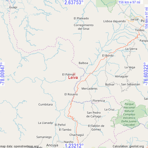
Leiva GPS coordinates[2]
1° 56' 5.892" North, 77° 18' 22.824" West
| Map corner | latitude | longitude |
|---|---|---|
| Upper-left | 2.63753°, | -78.00947° |
| Center: | 1.93497°, | -77.30634° |
| Lower-right: | 1.23212°, | -76.60322° |
| Map W x H: | 156.3×156.3 km | = 97.1×97.1mi |
| max Lat: | 13.38166° ⇑90.6% North |
| Leiva: | 1.93497° |
| min Lat: | ⇓9.4% South -4.21528° |
| min Long | Leiva | max Long |
| -81.70636° | -77.30634° | -67.06996° |
| W 5%⇐ | ⇒95% E |
Elevation
Elevation of Leiva is 1582 m = 5190 ft, and this is 432.7 m = 1420 ft above average elevation for this country.
| Max E: |
3342 m = 10965 ft | 35.8% |
| Leiva | 1582 m 5190 ft | |
| Avg. | 1149.3 m = 3771 ft | |
Min E: |
1 m = 3 ft | 64.2% |
See also: Colombia elevation on elevation.city.
Geographical zone
Leiva is located in North Torrid zone (between Equator and Tropic of Cancer). Distance of Equator is 215.1 km =133.7 mi to South.| Distance of | km | miles | from Leiva |
|---|---|---|---|
| North Pole | 9791.9 | 6084.4 | to North |
| Arctic Circle | 7186 | 4465.2 | to North |
| Tropic Cancer | 2390.8 | 1485.6 | to North |
| Equator | 215.1 | 133.7 | to South |


Nearby cities:
15 places around Leiva: (largest is in red/bold)
• Argelia
36.2 km =22.5 mi,  10°
10°
• Balboa
15.5 km =9.6 mi,  40°
40°
• Bolívar
39 km =24.2 mi,  105°
105°
• Cumbitara
44 km =27.3 mi,  223°
223°
• El Bordo
41.3 km =25.7 mi,  60°
60°
• El Rosario
21.5 km =13.4 mi,  188°
188°
• Florencia
38.1 km =23.7 mi,  137°
137°
• La Unión
41.6 km =25.8 mi,  152°
152°
• Mercaderes
21.2 km =13.2 mi,  134°
134°
• Patía
31.9 km =19.8 mi, 62°
• Policarpa
38.1 km =23.7 mi,  206°
206°
• Providencia
44.2 km =27.5 mi,  203°
203°
• San Pablo
43.7 km =27.2 mi, 131°
• Sucre
44 km =27.3 mi,  74°
74°
• Taminango
40.6 km =25.2 mi,  175°
175°
Sources, notices
• [Note1] Compared only with cities in Colombia existing in our database
• [Src1] Map data: © OpenStreetMap contributors (CC-BY-SA)
• [Src2] Other city data from geonames.org with taken over terms of usage.
• [Src3] Geographical zone / Annual Mean Temperature by Robert A. Rohde @ Wikipedia
