Balboa geodata
Balboa (Cauca) is a seat of a second-order administrative division; located in Colombia in America/Bogota (GMT-5) time zone. With population of 6,272 people, there are 435 cities with bigger population in this country. Compared to other cities in Colombia, 89.6% of cities are located further ↑North; 94.1% of cities are located further →East and 82.3% of cities have lower elevation than Balboa. Note1


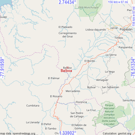
Balboa GPS coordinates[2]
2° 2' 30.588" North, 77° 12' 59.256" West
| Map corner | latitude | longitude |
|---|---|---|
| Upper-left | 2.74434°, | -77.91959° |
| Center: | 2.04183°, | -77.21646° |
| Lower-right: | 1.33902°, | -76.51334° |
| Map W x H: | 156.3×156.3 km | = 97.1×97.1mi |
| max Lat: | 13.38166° ⇑89.6% North |
| Balboa: | 2.04183° |
| min Lat: | ⇓10.4% South -4.21528° |
| min Long | Balboa | max Long |
| -81.70636° | -77.21646° | -67.06996° |
| W 5.9%⇐ | ⇒94.1% E |
Elevation
Elevation of Balboa is 2142 m = 7028 ft, and this is 992.7 m = 3257 ft above average elevation for this country.
| Max E: |
3342 m = 10965 ft | 17.7% |
| Balboa | 2142 m 7028 ft | |
| Avg. | 1149.3 m = 3771 ft | |
Min E: |
1 m = 3 ft | 82.3% |
See also: Colombia elevation on elevation.city.
Geographical zone
Balboa is located in North Torrid zone (between Equator and Tropic of Cancer). Distance of Equator is 227 km =141.1 mi to South.| Distance of | km | miles | from Balboa |
|---|---|---|---|
| North Pole | 9780 | 6077 | to North |
| Arctic Circle | 7174.1 | 4457.8 | to North |
| Tropic Cancer | 2378.9 | 1478.2 | to North |
| Equator | 227 | 141.1 | to South |


Nearby cities:
15 places around Balboa: (largest is in red/bold)
• Almaguer
42.6 km =26.5 mi,  109°
109°
• Argelia
24 km =14.9 mi,  351°
351°
• Bolívar
35.5 km =22.1 mi,  129°
129°
• El Bordo
27.3 km =17 mi,  72°
72°
• El Rosario
35.6 km =22.1 mi,  201°
201°
• Florencia
42.9 km =26.7 mi,  158°
158°
• Génova
49.4 km =30.7 mi,  153°
153°
• La Sierra
52.7 km =32.7 mi, 73°
• La Unión
49.5 km =30.8 mi,  169°
169°
• La Vega
48.8 km =30.3 mi,  95°
95°
• Leiva
15.5 km =9.6 mi,  220°
220°
• Mercaderes
27.2 km =16.9 mi, 169°
• Patía
18.4 km =11.4 mi,  80°
80°
• San Pablo
46.8 km =29.1 mi, 151°
• Sucre
32.4 km =20.1 mi,  90°
90°
Sources, notices
• [Note1] Compared only with cities in Colombia existing in our database
• [Src1] Map data: © OpenStreetMap contributors (CC-BY-SA)
• [Src2] Other city data from geonames.org with taken over terms of usage.
• [Src3] Geographical zone / Annual Mean Temperature by Robert A. Rohde @ Wikipedia
