Suárez geodata
Suárez (Tolima) is a seat of a second-order administrative division; located in Colombia in America/Bogota (GMT-5) time zone. With population of 1,243 people, there are 908 cities with bigger population in this country. Compared to other cities in Colombia, 77.7% of cities are located further ↑North; 50.1% of cities are located further →East and 70.1% of cities have higher elevation than Suárez. Note1


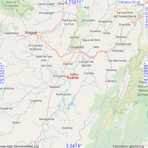
Suárez GPS coordinates[2]
4° 2' 56.616" North, 74° 49' 55.128" West
| Map corner | latitude | longitude |
|---|---|---|
| Upper-left | 4.75011°, | -75.53511° |
| Center: | 4.04906°, | -74.83198° |
| Lower-right: | 3.3474°, | -74.12886° |
| Map W x H: | 156×156 km | = 96.9×96.9mi |
| max Lat: | 13.38166° ⇑77.7% North |
| Suárez: | 4.04906° |
| min Lat: | ⇓22.3% South -4.21528° |
| min Long | Suárez | max Long |
| -81.70636° | -74.83198° | -67.06996° |
| W 49.9%⇐ | ⇒50.1% E |
Elevation
Elevation of Suárez is 292 m = 958 ft, and this is 857.3 m = 2813 ft below average elevation for this country.
| Max E: |
3342 m = 10965 ft | 70.1% |
| Avg. | 1149.3 m = 3771 ft | |
| Suárez | 292 m = 958 ft | |
Min E: |
1 m = 3 ft | 29.9% |
See also: Colombia elevation on elevation.city.
Geographical zone
Suárez is located in North Torrid zone (between Equator and Tropic of Cancer). Distance of Equator is 450.2 km =279.7 mi to South.| Distance of | km | miles | from Suárez |
|---|---|---|---|
| North Pole | 9556.8 | 5938.3 | to North |
| Arctic Circle | 6951 | 4319.1 | to North |
| Tropic Cancer | 2155.7 | 1339.5 | to North |
| Equator | 450.2 | 279.7 | to South |


Nearby cities:
15 places around Suárez: (largest is in red/bold)
• Carmen de Apicalá
16.5 km =10.3 mi,  48°
48°
• Chicoral
24.9 km =15.5 mi,  318°
318°
• Coello
27.7 km =17.2 mi,  344°
344°
• Cunday
15.6 km =9.7 mi,  85°
85°
• Espinal
12.6 km =7.8 mi,  332°
332°
• Flandes
26.9 km =16.7 mi,  3°
3°
• Girardot City
28.1 km =17.5 mi,  5°
5°
• Guamo
15.5 km =9.6 mi,  262°
262°
• La Chamba
4.8 km =3 mi,  238°
238°
• Melgar
27.4 km =17 mi, 50°
• Purificación
23.9 km =14.9 mi,  207°
207°
• Ricaurte
26.8 km =16.7 mi,  16°
16°
• Saldaña
24.3 km =15.1 mi, 236°
• Tres Esquinas
24.6 km =15.3 mi,  146°
146°
• Villarrica
28.7 km =17.8 mi,  116°
116°
Sources, notices
• [Note1] Compared only with cities in Colombia existing in our database
• [Src1] Map data: © OpenStreetMap contributors (CC-BY-SA)
• [Src2] Other city data from geonames.org with taken over terms of usage.
• [Src3] Geographical zone / Annual Mean Temperature by Robert A. Rohde @ Wikipedia
