Espinal geodata
Espinal (Tolima) is a seat of a second-order administrative division; located in Colombia in America/Bogota (GMT-5) time zone. With population of 56,213 people, there are 71 cities with bigger population in this country. Compared to other cities in Colombia, 76.9% of cities are located further ↑North; 51.2% of cities are located further →East and 68.6% of cities have higher elevation than Espinal. Note1


Espinal GPS coordinates[2]
4° 8' 57.264" North, 74° 53' 3.444" West
| Map corner | latitude | longitude |
|---|---|---|
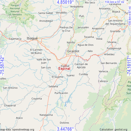
| Upper-left | 4.85019°, | -75.58742° |
| Center: | 4.14924°, | -74.88429° |
| Lower-right: | 3.44766°, | -74.18117° |
| Map W x H: | 155.9×156 km | = 96.9×96.9mi |
| max Lat: | 13.38166° ⇑76.9% North |
| Espinal: | 4.14924° |
| min Lat: | ⇓23.1% South -4.21528° |
| min Long | Espinal | max Long |
| -81.70636° | -74.88429° | -67.06996° |
| W 48.8%⇐ | ⇒51.2% E |
Elevation
Elevation of Espinal is 323 m = 1060 ft, and this is 826.3 m = 2711 ft below average elevation for this country.
| Max E: |
3342 m = 10965 ft | 68.6% |
| Avg. | 1149.3 m = 3771 ft | |
| Espinal | 323 m = 1060 ft | |
Min E: |
1 m = 3 ft | 31.4% |
See also: Espinal elevation on elevation.city.
Geographical zone
Espinal is located in North Torrid zone (between Equator and Tropic of Cancer). Distance of Equator is 461.4 km =286.7 mi to South.| Distance of | km | miles | from Espinal |
|---|---|---|---|
| North Pole | 9545.7 | 5931.4 | to North |
| Arctic Circle | 6939.8 | 4312.2 | to North |
| Tropic Cancer | 2144.6 | 1332.6 | to North |
| Equator | 461.4 | 286.7 | to South |


Nearby cities:
15 places around Espinal: (largest is in red/bold)
• Carmen de Apicalá
18.2 km =11.3 mi,  90°
90°
• Chicoral
13.1 km =8.1 mi,  304°
304°
• Coello
15.6 km =9.7 mi,  354°
354°
• Cunday
23.5 km =14.6 mi,  114°
114°
• Flandes
17.4 km =10.8 mi,  25°
25°
• Girardot City
18.9 km =11.7 mi, 26°
• Guamo
16.2 km =10.1 mi,  215°
215°
• La Chamba
13.8 km =8.6 mi,  172°
172°
• Melgar
27.7 km =17.2 mi,  77°
77°
• Nariño
28.4 km =17.6 mi,  12°
12°
• Ricaurte
19.7 km =12.2 mi,  42°
42°
• Saldaña
28.4 km =17.6 mi,  210°
210°
• San Luis
23.4 km =14.5 mi,  265°
265°
• Suárez
12.6 km =7.8 mi,  152°
152°
• Valle de San Juan
26.4 km =16.4 mi,  282°
282°
Sources, notices
• [Note1] Compared only with cities in Colombia existing in our database
• [Src1] Map data: © OpenStreetMap contributors (CC-BY-SA)
• [Src2] Other city data from geonames.org with taken over terms of usage.
• [Src3] Geographical zone / Annual Mean Temperature by Robert A. Rohde @ Wikipedia
