Landázuri geodata
Landázuri (Santander) is a seat of a second-order administrative division; located in Colombia in America/Bogota (GMT-5) time zone. With population of 3,483 people, there are 635 cities with bigger population in this country. Compared to other cities in Colombia, 63.3% of cities are located further ↓South; 69.7% of cities are located further ←West and 56.5% of cities have higher elevation than Landázuri. Note1


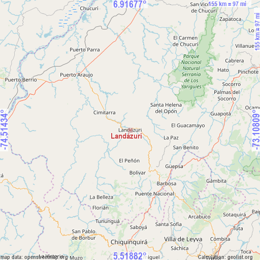
Landázuri GPS coordinates[2]
6° 13' 5.736" North, 73° 48' 40.356" West
| Map corner | latitude | longitude |
|---|---|---|
| Upper-left | 6.91677°, | -74.51434° |
| Center: | 6.21826°, | -73.81121° |
| Lower-right: | 5.51882°, | -73.10809° |
| Map W x H: | 155.4×155.4 km | = 96.6×96.6mi |
| max Lat: | 13.38166° ⇑36.7% North |
| Landázuri: | 6.21826° |
| min Lat: | ⇓63.3% South -4.21528° |
| min Long | Landázuri | max Long |
| -81.70636° | -73.81121° | -67.06996° |
| W 69.7%⇐ | ⇒30.3% E |
Elevation
Elevation of Landázuri is 945 m = 3100 ft, and this is 204.3 m = 670 ft below average elevation for this country.
| Max E: |
3342 m = 10965 ft | 56.5% |
| Avg. | 1149.3 m = 3771 ft | |
| Landázuri | 945 m = 3100 ft | |
Min E: |
1 m = 3 ft | 43.5% |
See also: Colombia elevation on elevation.city.
Geographical zone
Landázuri is located in North Torrid zone (between Equator and Tropic of Cancer). Distance of Equator is 691.4 km =429.6 mi to South.| Distance of | km | miles | from Landázuri |
|---|---|---|---|
| North Pole | 9315.7 | 5788.5 | to North |
| Arctic Circle | 6709.8 | 4169.3 | to North |
| Tropic Cancer | 1914.5 | 1189.6 | to North |
| Equator | 691.4 | 429.6 | to South |


Nearby cities:
15 places around Landázuri: (largest is in red/bold)
• Aguada
32.6 km =20.3 mi,  101°
101°
• Bolívar
25.9 km =16.1 mi,  169°
169°
• Chipatá
25.9 km =16.1 mi,  132°
132°
• Cimitarra
18.7 km =11.6 mi,  304°
304°
• El Guacamayo
34.9 km =21.7 mi,  85°
85°
• El Peñón
18.2 km =11.3 mi,  181°
181°
• Guavatá
31.7 km =19.7 mi,  157°
157°
• Güepsa
34 km =21.1 mi, 129°
• La Paz
24.9 km =15.5 mi, 100°
• San Benito
36.7 km =22.8 mi,  105°
105°
• San José de Pare
36.8 km =22.9 mi, 127°
• Santa Helena
26.8 km =16.7 mi,  70°
70°
• Santa Helena del Opón
25.4 km =15.8 mi,  57°
57°
• Sucre
33.4 km =20.8 mi, 176°
• Vélez
27.4 km =17 mi,  146°
146°
Sources, notices
• [Note1] Compared only with cities in Colombia existing in our database
• [Src1] Map data: © OpenStreetMap contributors (CC-BY-SA)
• [Src2] Other city data from geonames.org with taken over terms of usage.
• [Src3] Geographical zone / Annual Mean Temperature by Robert A. Rohde @ Wikipedia
