Vélez geodata
Vélez (Santander) is a seat of a second-order administrative division; located in Colombia in America/Bogota (GMT-5) time zone. With population of 10,905 people, there are 282 cities with bigger population in this country. Compared to other cities in Colombia, 59.5% of cities are located further ↓South; 72.1% of cities are located further ←West and 83.1% of cities have lower elevation than Vélez. Note1


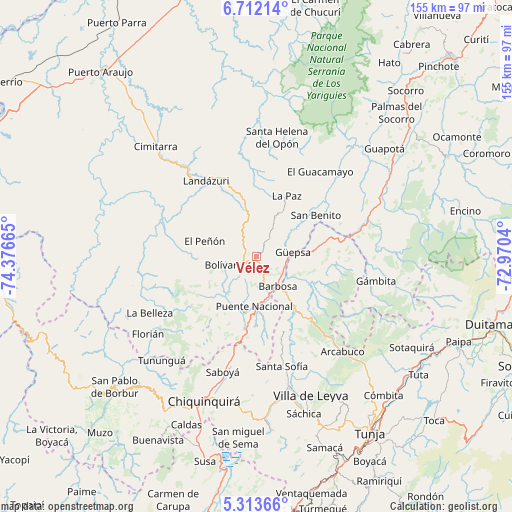
Vélez GPS coordinates[2]
6° 0' 48.06" North, 73° 40' 24.672" West
| Map corner | latitude | longitude |
|---|---|---|
| Upper-left | 6.71214°, | -74.37665° |
| Center: | 6.01335°, | -73.67352° |
| Lower-right: | 5.31366°, | -72.9704° |
| Map W x H: | 155.5×155.5 km | = 96.6×96.6mi |
| max Lat: | 13.38166° ⇑40.5% North |
| Vélez: | 6.01335° |
| min Lat: | ⇓59.5% South -4.21528° |
| min Long | Vélez | max Long |
| -81.70636° | -73.67352° | -67.06996° |
| W 72.1%⇐ | ⇒27.9% E |
Elevation
Elevation of Vélez is 2160 m = 7087 ft, and this is 1010.7 m = 3316 ft above average elevation for this country.
| Max E: |
3342 m = 10965 ft | 16.9% |
| Vélez | 2160 m 7087 ft | |
| Avg. | 1149.3 m = 3771 ft | |
Min E: |
1 m = 3 ft | 83.1% |
See also: Colombia elevation on elevation.city.
Geographical zone
Vélez is located in North Torrid zone (between Equator and Tropic of Cancer). Distance of Equator is 668.6 km =415.4 mi to South.| Distance of | km | miles | from Vélez |
|---|---|---|---|
| North Pole | 9338.4 | 5802.6 | to North |
| Arctic Circle | 6732.6 | 4183.4 | to North |
| Tropic Cancer | 1937.3 | 1203.8 | to North |
| Equator | 668.6 | 415.4 | to South |


Nearby cities:
15 places around Vélez: (largest is in red/bold)
• Aguada
23.6 km =14.7 mi,  45°
45°
• Barbosa
11.1 km =6.9 mi,  144°
144°
• Bolívar
11.1 km =6.9 mi,  256°
256°
• Chipatá
6.7 km =4.2 mi,  36°
36°
• El Peñón
16.3 km =10.1 mi,  286°
286°
• Guavatá
7.1 km =4.4 mi,  204°
204°
• Güepsa
11.2 km =7 mi,  83°
83°
• Jesús María
19.2 km =11.9 mi,  218°
218°
• La Paz
20.6 km =12.8 mi,  26°
26°
• Moniquirá
18.9 km =11.7 mi, 143°
• Puente Nacional
15.1 km =9.4 mi,  181°
181°
• San José de Pare
14 km =8.7 mi,  88°
88°
• Santana
21.8 km =13.5 mi, 77°
• Sucre
16.8 km =10.4 mi,  230°
230°
• Togüí
19.8 km =12.3 mi,  116°
116°
Sources, notices
• [Note1] Compared only with cities in Colombia existing in our database
• [Src1] Map data: © OpenStreetMap contributors (CC-BY-SA)
• [Src2] Other city data from geonames.org with taken over terms of usage.
• [Src3] Geographical zone / Annual Mean Temperature by Robert A. Rohde @ Wikipedia
