Cimitarra geodata
Cimitarra (Santander) is a seat of a second-order administrative division; located in Colombia in America/Bogota (GMT-5) time zone. With population of 11,267 people, there are 269 cities with bigger population in this country. Compared to other cities in Colombia, 64.9% of cities are located further ↓South; 65.9% of cities are located further ←West and 77.1% of cities have higher elevation than Cimitarra. Note1


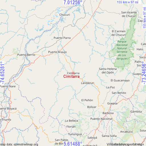
Cimitarra GPS coordinates[2]
6° 18' 51.084" North, 73° 56' 58.848" West
| Map corner | latitude | longitude |
|---|---|---|
| Upper-left | 7.01256°, | -74.65281° |
| Center: | 6.31419°, | -73.94968° |
| Lower-right: | 5.61488°, | -73.24656° |
| Map W x H: | 155.4×155.4 km | = 96.6×96.6mi |
| max Lat: | 13.38166° ⇑35.1% North |
| Cimitarra: | 6.31419° |
| min Lat: | ⇓64.9% South -4.21528° |
| min Long | Cimitarra | max Long |
| -81.70636° | -73.94968° | -67.06996° |
| W 65.9%⇐ | ⇒34.1% E |
Elevation
Elevation of Cimitarra is 156 m = 512 ft, and this is 993.3 m = 3259 ft below average elevation for this country.
| Max E: |
3342 m = 10965 ft | 77.1% |
| Avg. | 1149.3 m = 3771 ft | |
| Cimitarra | 156 m = 512 ft | |
Min E: |
1 m = 3 ft | 22.9% |
See also: Colombia elevation on elevation.city.
Geographical zone
Cimitarra is located in North Torrid zone (between Equator and Tropic of Cancer). Distance of Equator is 702.1 km =436.3 mi to South.| Distance of | km | miles | from Cimitarra |
|---|---|---|---|
| North Pole | 9305 | 5781.9 | to North |
| Arctic Circle | 6699.1 | 4162.6 | to North |
| Tropic Cancer | 1903.8 | 1183 | to North |
| Equator | 702.1 | 436.3 | to South |


Nearby cities:
15 places around Cimitarra: (largest is in red/bold)
• Aguada
50.2 km =31.2 mi,  109°
109°
• Bolívar
41.2 km =25.6 mi,  151°
151°
• Chipatá
44.5 km =27.7 mi,  129°
129°
• El Guacamayo
50.7 km =31.5 mi,  98°
98°
• El Peñón
32.4 km =20.1 mi, 152°
• Guavatá
48.5 km =30.1 mi, 145°
• Jesús María
52.1 km =32.4 mi,  159°
159°
• La Belleza
50.1 km =31.1 mi,  181°
181°
• La Paz
42.6 km =26.5 mi, 110°
• Landázuri
18.7 km =11.6 mi,  124°
124°
• Puerto Parra
39.3 km =24.4 mi,  342°
342°
• Santa Helena
40.5 km =25.2 mi,  92°
92°
• Santa Helena del Opón
36.9 km =22.9 mi, 85°
• Sucre
47.4 km =29.5 mi, 158°
• Vélez
45.3 km =28.1 mi,  137°
137°
Sources, notices
• [Note1] Compared only with cities in Colombia existing in our database
• [Src1] Map data: © OpenStreetMap contributors (CC-BY-SA)
• [Src2] Other city data from geonames.org with taken over terms of usage.
• [Src3] Geographical zone / Annual Mean Temperature by Robert A. Rohde @ Wikipedia
