Bolívar geodata
Bolívar (Santander) is a seat of a second-order administrative division; located in Colombia in America/Bogota (GMT-5) time zone. With population of 2,230 people, there are 773 cities with bigger population in this country. Compared to other cities in Colombia, 59.2% of cities are located further ↓South; 70.5% of cities are located further ←West and 82.1% of cities have lower elevation than Bolívar. Note1


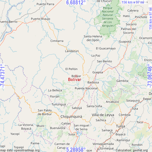
Bolívar GPS coordinates[2]
5° 59' 21.48" North, 73° 46' 14.088" West
| Map corner | latitude | longitude |
|---|---|---|
| Upper-left | 6.68812°, | -74.47371° |
| Center: | 5.9893°, | -73.77058° |
| Lower-right: | 5.28958°, | -73.06746° |
| Map W x H: | 155.5×155.5 km | = 96.6×96.6mi |
| max Lat: | 13.38166° ⇑40.8% North |
| Bolívar: | 5.9893° |
| min Lat: | ⇓59.2% South -4.21528° |
| min Long | Bolívar | max Long |
| -81.70636° | -73.77058° | -67.06996° |
| W 70.5%⇐ | ⇒29.5% E |
Elevation
Elevation of Bolívar is 2135 m = 7005 ft, and this is 985.7 m = 3234 ft above average elevation for this country.
| Max E: |
3342 m = 10965 ft | 17.9% |
| Bolívar | 2135 m 7005 ft | |
| Avg. | 1149.3 m = 3771 ft | |
Min E: |
1 m = 3 ft | 82.1% |
See also: Colombia elevation on elevation.city.
Geographical zone
Bolívar is located in North Torrid zone (between Equator and Tropic of Cancer). Distance of Equator is 665.9 km =413.8 mi to South.| Distance of | km | miles | from Bolívar |
|---|---|---|---|
| North Pole | 9341.1 | 5804.3 | to North |
| Arctic Circle | 6735.2 | 4185.1 | to North |
| Tropic Cancer | 1940 | 1205.5 | to North |
| Equator | 665.9 | 413.8 | to South |


Nearby cities:
15 places around Bolívar: (largest is in red/bold)
• Barbosa
18.4 km =11.4 mi,  110°
110°
• Chipatá
16.8 km =10.4 mi,  61°
61°
• El Peñón
8.8 km =5.5 mi,  325°
325°
• Guavatá
8.7 km =5.4 mi,  116°
116°
• Güepsa
22.2 km =13.8 mi,  79°
79°
• Jesús María
12.5 km =7.8 mi,  185°
185°
• La Belleza
25.3 km =15.7 mi,  236°
236°
• La Paz
29 km =18 mi,  43°
43°
• Landázuri
25.9 km =16.1 mi,  349°
349°
• Moniquirá
25.2 km =15.7 mi, 119°
• Puente Nacional
16.1 km =10 mi,  140°
140°
• San José de Pare
24.9 km =15.5 mi, 82°
• Sucre
8.2 km =5.1 mi,  196°
196°
• Togüí
29.1 km =18.1 mi,  102°
102°
• Vélez
11.1 km =6.9 mi, 76°
Sources, notices
• [Note1] Compared only with cities in Colombia existing in our database
• [Src1] Map data: © OpenStreetMap contributors (CC-BY-SA)
• [Src2] Other city data from geonames.org with taken over terms of usage.
• [Src3] Geographical zone / Annual Mean Temperature by Robert A. Rohde @ Wikipedia
