Cúcuta geodata
Cúcuta (Norte de Santander) is a seat of a first-order administrative division; located in Colombia in America/Bogota (GMT-5) time zone. With population of 721,398 people, there are 5 cities with bigger population in this country. Compared to other cities in Colombia, 80.2% of cities are located further ↓South; 95.2% of cities are located further ←West and 69.2% of cities have higher elevation than Cúcuta. Note1


Cúcuta GPS coordinates[2]
7° 53' 38.076" North, 72° 30' 28.152" West
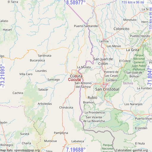
| Map corner | latitude | longitude |
|---|---|---|
| Upper-left | 8.58977°, | -73.21095° |
| Center: | 7.89391°, | -72.50782° |
| Lower-right: | 7.19688°, | -71.8047° |
| Map W x H: | 154.9×154.9 km | = 96.3×96.3mi |
| max Lat: | 13.38166° ⇑19.8% North |
| Cúcuta: | 7.89391° |
| min Lat: | ⇓80.2% South -4.21528° |
| min Long | Cúcuta | max Long |
| -81.70636° | -72.50782° | -67.06996° |
| W 95.2%⇐ | ⇒4.8% E |
Elevation
Elevation of Cúcuta is 309 m = 1014 ft, and this is 840.3 m = 2757 ft below average elevation for this country.
| Max E: |
3342 m = 10965 ft | 69.2% |
| Avg. | 1149.3 m = 3771 ft | |
| Cúcuta | 309 m = 1014 ft | |
Min E: |
1 m = 3 ft | 30.8% |
See also: Cúcuta elevation on elevation.city.
Geographical zone
Cúcuta is located in North Torrid zone (between Equator and Tropic of Cancer). Distance of Equator is 877.7 km =545.4 mi to South.| Distance of | km | miles | from Cúcuta |
|---|---|---|---|
| North Pole | 9129.3 | 5672.7 | to North |
| Arctic Circle | 6523.5 | 4053.5 | to North |
| Tropic Cancer | 1728.2 | 1073.9 | to North |
| Equator | 877.7 | 545.4 | to South |


Nearby cities:
15 places around Cúcuta: (largest is in red/bold)
• Arboledas
42.6 km =26.5 mi,  228°
228°
• Bochalema
35 km =21.7 mi,  206°
206°
• Bucarasica
42.6 km =26.5 mi,  292°
292°
• Chinácota
33.5 km =20.8 mi,  197°
197°
• Durania
26 km =16.2 mi,  219°
219°
• El Zulia
11.1 km =6.9 mi, 292°
• Gramalote
31.9 km =19.8 mi,  268°
268°
• La Esperanza
35.5 km =22.1 mi,  7°
7°
• Los Patios
6.2 km =3.9 mi,  175°
175°
• Lourdes
36.2 km =22.5 mi,  278°
278°
• Ragonvalia
35.4 km =22 mi,  174°
174°
• San Cayetano
13 km =8.1 mi,  261°
261°
• Santiago
23.2 km =14.4 mi, 261°
• Sardinata
38.5 km =23.9 mi,  303°
303°
• Villa del Rosario
7.6 km =4.7 mi,  150°
150°
Sources, notices
• [Note1] Compared only with cities in Colombia existing in our database
• [Src1] Map data: © OpenStreetMap contributors (CC-BY-SA)
• [Src2] Other city data from geonames.org with taken over terms of usage.
• [Src3] Geographical zone / Annual Mean Temperature by Robert A. Rohde @ Wikipedia
