Los Patios geodata
Los Patios (Norte de Santander) is a seat of a second-order administrative division; located in Colombia in America/Bogota (GMT-5) time zone. With population of 58,661 people, there are 67 cities with bigger population in this country. Compared to other cities in Colombia, 79.6% of cities are located further ↓South; 95.5% of cities are located further ←West and 66.4% of cities have higher elevation than Los Patios. Note1


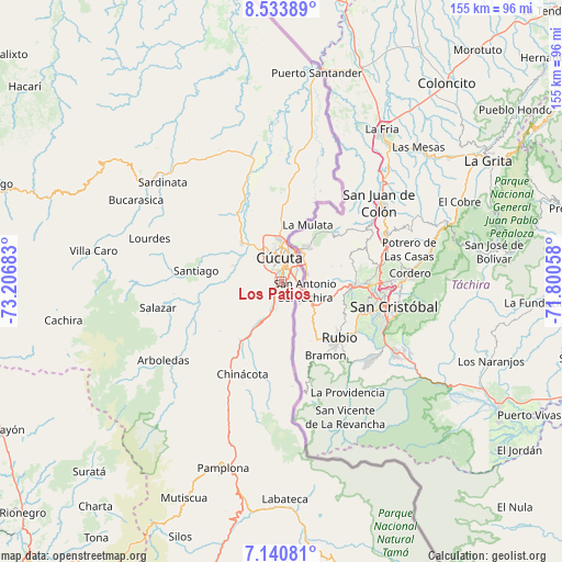
Los Patios GPS coordinates[2]
7° 50' 16.548" North, 72° 30' 13.32" West
| Map corner | latitude | longitude |
|---|---|---|
| Upper-left | 8.53389°, | -73.20683° |
| Center: | 7.83793°, | -72.5037° |
| Lower-right: | 7.14081°, | -71.80058° |
| Map W x H: | 154.9×154.9 km | = 96.3×96.3mi |
| max Lat: | 13.38166° ⇑20.4% North |
| Los Patios: | 7.83793° |
| min Lat: | ⇓79.6% South -4.21528° |
| min Long | Los Patios | max Long |
| -81.70636° | -72.5037° | -67.06996° |
| W 95.5%⇐ | ⇒4.5% E |
Elevation
Elevation of Los Patios is 395 m = 1296 ft, and this is 754.3 m = 2475 ft below average elevation for this country.
| Max E: |
3342 m = 10965 ft | 66.4% |
| Avg. | 1149.3 m = 3771 ft | |
| Los Patios | 395 m = 1296 ft | |
Min E: |
1 m = 3 ft | 33.6% |
See also: Los Patios elevation on elevation.city.
Geographical zone
Los Patios is located in North Torrid zone (between Equator and Tropic of Cancer). Distance of Equator is 871.5 km =541.5 mi to South.| Distance of | km | miles | from Los Patios |
|---|---|---|---|
| North Pole | 9135.6 | 5676.6 | to North |
| Arctic Circle | 6529.7 | 4057.4 | to North |
| Tropic Cancer | 1734.4 | 1077.7 | to North |
| Equator | 871.5 | 541.5 | to South |


Nearby cities:
15 places around Los Patios: (largest is in red/bold)
• Arboledas
39.2 km =24.4 mi,  236°
236°
• Bochalema
29.8 km =18.5 mi,  212°
212°
• Chinácota
27.8 km =17.3 mi,  202°
202°
• Cúcuta
6.2 km =3.9 mi,  355°
355°
• Durania
21.9 km =13.6 mi,  230°
230°
• El Zulia
15 km =9.3 mi,  314°
314°
• Gramalote
32.8 km =20.4 mi,  279°
279°
• Herrán
37 km =23 mi,  176°
176°
• La Esperanza
41.6 km =25.8 mi,  6°
6°
• Lourdes
38.1 km =23.7 mi,  288°
288°
• Ragonvalia
29.1 km =18.1 mi,  173°
173°
• San Cayetano
14 km =8.7 mi, 288°
• Santiago
23.6 km =14.7 mi, 277°
• Sardinata
42.6 km =26.5 mi, 309°
• Villa del Rosario
3.3 km =2.1 mi,  97°
97°
Sources, notices
• [Note1] Compared only with cities in Colombia existing in our database
• [Src1] Map data: © OpenStreetMap contributors (CC-BY-SA)
• [Src2] Other city data from geonames.org with taken over terms of usage.
• [Src3] Geographical zone / Annual Mean Temperature by Robert A. Rohde @ Wikipedia
