San Juanito geodata
San Juanito (Meta) is a seat of a second-order administrative division; located in Colombia in America/Bogota (GMT-5) time zone. In our database, there are 1053 cities with bigger population. Compared to other cities in Colombia, 71.8% of cities are located further ↑North; 71.9% of cities are located further ←West and 79.4% of cities have lower elevation than San Juanito. Note1


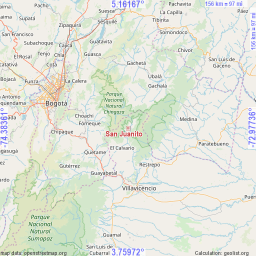
San Juanito GPS coordinates[2]
4° 27' 39.708" North, 73° 40' 49.728" West
| Map corner | latitude | longitude |
|---|---|---|
| Upper-left | 5.16167°, | -74.38361° |
| Center: | 4.46103°, | -73.68048° |
| Lower-right: | 3.75972°, | -72.97736° |
| Map W x H: | 155.9×155.9 km | = 96.9×96.9mi |
| max Lat: | 13.38166° ⇑71.8% North |
| San Juanito: | 4.46103° |
| min Lat: | ⇓28.2% South -4.21528° |
| min Long | San Juanito | max Long |
| -81.70636° | -73.68048° | -67.06996° |
| W 71.9%⇐ | ⇒28.1% E |
Elevation
Elevation of San Juanito is 2018 m = 6621 ft, and this is 868.7 m = 2850 ft above average elevation for this country.
| Max E: |
3342 m = 10965 ft | 20.6% |
| San Juanito | 2018 m 6621 ft | |
| Avg. | 1149.3 m = 3771 ft | |
Min E: |
1 m = 3 ft | 79.4% |
See also: Colombia elevation on elevation.city.
Geographical zone
San Juanito is located in North Torrid zone (between Equator and Tropic of Cancer). Distance of Equator is 496 km =308.2 mi to South.| Distance of | km | miles | from San Juanito |
|---|---|---|---|
| North Pole | 9511 | 5909.9 | to North |
| Arctic Circle | 6905.2 | 4290.7 | to North |
| Tropic Cancer | 2109.9 | 1311 | to North |
| Equator | 496 | 308.2 | to South |


Nearby cities:
15 places around San Juanito: (largest is in red/bold)
• Choachí
27.9 km =17.3 mi,  285°
285°
• Cumaral
30.1 km =18.7 mi,  134°
134°
• Cáqueza
30.2 km =18.8 mi,  258°
258°
• El Calvario
12.4 km =7.7 mi,  196°
196°
• Fosca
31.7 km =19.7 mi,  244°
244°
• Fómeque
24.2 km =15 mi,  277°
277°
• Gachalá
31.3 km =19.4 mi,  34°
34°
• Gama
34.4 km =21.4 mi,  12°
12°
• Guayabetal
31.3 km =19.4 mi,  208°
208°
• Junín
36.7 km =22.8 mi,  3°
3°
• Quetame
24.6 km =15.3 mi,  234°
234°
• Restrepo
26.1 km =16.2 mi,  149°
149°
• Ubalá
35.4 km =22 mi, 27°
• Ubaque
28.6 km =17.8 mi, 275°
• Villavicencio
36 km =22.4 mi,  170°
170°
Sources, notices
• [Note1] Compared only with cities in Colombia existing in our database
• [Src1] Map data: © OpenStreetMap contributors (CC-BY-SA)
• [Src2] Other city data from geonames.org with taken over terms of usage.
• [Src3] Geographical zone / Annual Mean Temperature by Robert A. Rohde @ Wikipedia
