El Rosal geodata
El Rosal (Cundinamarca) is a seat of a second-order administrative division; located in Colombia in America/Bogota (GMT-5) time zone. With population of 5,552 people, there are 473 cities with bigger population in this country. Compared to other cities in Colombia, 65.7% of cities are located further ↑North; 61% of cities are located further ←West and 93.7% of cities have lower elevation than El Rosal. Note1


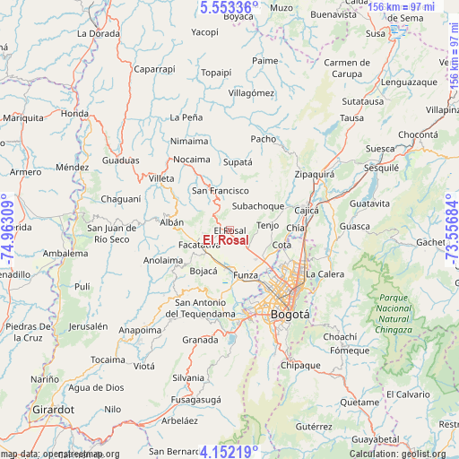
El Rosal GPS coordinates[2]
4° 51' 11.304" North, 74° 15' 35.856" West
| Map corner | latitude | longitude |
|---|---|---|
| Upper-left | 5.55336°, | -74.96309° |
| Center: | 4.85314°, | -74.25996° |
| Lower-right: | 4.15219°, | -73.55684° |
| Map W x H: | 155.8×155.8 km | = 96.8×96.8mi |
| max Lat: | 13.38166° ⇑65.7% North |
| El Rosal: | 4.85314° |
| min Lat: | ⇓34.3% South -4.21528° |
| min Long | El Rosal | max Long |
| -81.70636° | -74.25996° | -67.06996° |
| W 61%⇐ | ⇒39% E |
Elevation
Elevation of El Rosal is 2612 m = 8570 ft, and this is 1462.7 m = 4799 ft above average elevation for this country.
| Max E: |
3342 m = 10965 ft | 6.3% |
| El Rosal | 2612 m 8570 ft | |
| Avg. | 1149.3 m = 3771 ft | |
Min E: |
1 m = 3 ft | 93.7% |
See also: Colombia elevation on elevation.city.
Geographical zone
El Rosal is located in North Torrid zone (between Equator and Tropic of Cancer). Distance of Equator is 539.6 km =335.3 mi to South.| Distance of | km | miles | from El Rosal |
|---|---|---|---|
| North Pole | 9467.4 | 5882.8 | to North |
| Arctic Circle | 6861.6 | 4263.6 | to North |
| Tropic Cancer | 2066.3 | 1283.9 | to North |
| Equator | 539.6 | 335.3 | to South |


Nearby cities:
15 places around El Rosal: (largest is in red/bold)
• Albán
19.9 km =12.4 mi,  277°
277°
• Bojacá
16.2 km =10.1 mi,  213°
213°
• Chía
22.3 km =13.9 mi,  88°
88°
• Cota
18.6 km =11.6 mi,  105°
105°
• Facatativá
11.4 km =7.1 mi,  247°
247°
• Funza
16.1 km =10 mi,  160°
160°
• Guayabal de Síquima
23.1 km =14.4 mi, 276°
• La Vega
18.8 km =11.7 mi,  331°
331°
• Madrid
13.4 km =8.3 mi,  182°
182°
• Mosquera
16.7 km =10.4 mi,  168°
168°
• San Francisco
14.4 km =8.9 mi,  345°
345°
• Subachoque
12.6 km =7.8 mi,  49°
49°
• Tabio
19.8 km =12.3 mi,  68°
68°
• Tenjo
13 km =8.1 mi,  80°
80°
• Zipacón
17 km =10.6 mi,  231°
231°
Sources, notices
• [Note1] Compared only with cities in Colombia existing in our database
• [Src1] Map data: © OpenStreetMap contributors (CC-BY-SA)
• [Src2] Other city data from geonames.org with taken over terms of usage.
• [Src3] Geographical zone / Annual Mean Temperature by Robert A. Rohde @ Wikipedia
