Mosquera geodata
Mosquera (Cundinamarca) is a seat of a second-order administrative division; located in Colombia in America/Bogota (GMT-5) time zone. With population of 27,005 people, there are 136 cities with bigger population in this country. Compared to other cities in Colombia, 68.3% of cities are located further ↑North; 61.5% of cities are located further ←West and 90% of cities have lower elevation than Mosquera. Note1


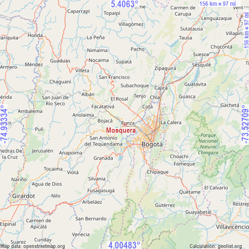
Mosquera GPS coordinates[2]
4° 42' 21.312" North, 74° 13' 48.756" West
| Map corner | latitude | longitude |
|---|---|---|
| Upper-left | 5.4063°, | -74.93334° |
| Center: | 4.70592°, | -74.23021° |
| Lower-right: | 4.00483°, | -73.52709° |
| Map W x H: | 155.8×155.8 km | = 96.8×96.8mi |
| max Lat: | 13.38166° ⇑68.3% North |
| Mosquera: | 4.70592° |
| min Lat: | ⇓31.7% South -4.21528° |
| min Long | Mosquera | max Long |
| -81.70636° | -74.23021° | -67.06996° |
| W 61.5%⇐ | ⇒38.5% E |
Elevation
Elevation of Mosquera is 2544 m = 8346 ft, and this is 1394.7 m = 4576 ft above average elevation for this country.
| Max E: |
3342 m = 10965 ft | 10% |
| Mosquera | 2544 m 8346 ft | |
| Avg. | 1149.3 m = 3771 ft | |
Min E: |
1 m = 3 ft | 90% |
See also: Colombia elevation on elevation.city.
Geographical zone
Mosquera is located in North Torrid zone (between Equator and Tropic of Cancer). Distance of Equator is 523.2 km =325.1 mi to South.| Distance of | km | miles | from Mosquera |
|---|---|---|---|
| North Pole | 9483.8 | 5893 | to North |
| Arctic Circle | 6877.9 | 4273.7 | to North |
| Tropic Cancer | 2082.7 | 1294.1 | to North |
| Equator | 523.2 | 325.1 | to South |


Nearby cities:
15 places around Mosquera: (largest is in red/bold)
• Barrio San Luis
23.5 km =14.6 mi,  100°
100°
• Bogotá
19.6 km =12.2 mi,  123°
123°
• Bojacá
12.6 km =7.8 mi,  283°
283°
• Cachipay
23 km =14.3 mi, 276°
• Cota
18.6 km =11.6 mi,  51°
51°
• El Rosal
16.7 km =10.4 mi,  348°
348°
• Facatativá
18.3 km =11.4 mi,  311°
311°
• Funza
2.3 km =1.4 mi,  60°
60°
• Madrid
4.8 km =3 mi, 308°
• San Antonio del Tequendama
16.8 km =10.4 mi,  233°
233°
• Sibaté
24.1 km =15 mi,  187°
187°
• Soacha
14.1 km =8.8 mi,  173°
173°
• Tena
18.7 km =11.6 mi,  254°
254°
• Tenjo
20.8 km =12.9 mi,  27°
27°
• Zipacón
17.6 km =10.9 mi,  289°
289°
Sources, notices
• [Note1] Compared only with cities in Colombia existing in our database
• [Src1] Map data: © OpenStreetMap contributors (CC-BY-SA)
• [Src2] Other city data from geonames.org with taken over terms of usage.
• [Src3] Geographical zone / Annual Mean Temperature by Robert A. Rohde @ Wikipedia
