Funza geodata
Funza (Cundinamarca) is a seat of a second-order administrative division; located in Colombia in America/Bogota (GMT-5) time zone. With population of 54,421 people, there are 75 cities with bigger population in this country. Compared to other cities in Colombia, 68.2% of cities are located further ↑North; 61.8% of cities are located further ←West and 90.2% of cities have lower elevation than Funza. Note1


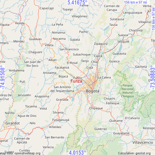
Funza GPS coordinates[2]
4° 42' 58.968" North, 74° 12' 43.02" West
| Map corner | latitude | longitude |
|---|---|---|
| Upper-left | 5.41675°, | -74.91508° |
| Center: | 4.71638°, | -74.21195° |
| Lower-right: | 4.0153°, | -73.50883° |
| Map W x H: | 155.8×155.8 km | = 96.8×96.8mi |
| max Lat: | 13.38166° ⇑68.2% North |
| Funza: | 4.71638° |
| min Lat: | ⇓31.8% South -4.21528° |
| min Long | Funza | max Long |
| -81.70636° | -74.21195° | -67.06996° |
| W 61.8%⇐ | ⇒38.2% E |
Elevation
Elevation of Funza is 2548 m = 8360 ft, and this is 1398.7 m = 4589 ft above average elevation for this country.
| Max E: |
3342 m = 10965 ft | 9.8% |
| Funza | 2548 m 8360 ft | |
| Avg. | 1149.3 m = 3771 ft | |
Min E: |
1 m = 3 ft | 90.2% |
See also: Funza elevation on elevation.city.
Geographical zone
Funza is located in North Torrid zone (between Equator and Tropic of Cancer). Distance of Equator is 524.4 km =325.8 mi to South.| Distance of | km | miles | from Funza |
|---|---|---|---|
| North Pole | 9482.6 | 5892.2 | to North |
| Arctic Circle | 6876.8 | 4273 | to North |
| Tropic Cancer | 2081.5 | 1293.4 | to North |
| Equator | 524.4 | 325.8 | to South |


Nearby cities:
15 places around Funza: (largest is in red/bold)
• Barrio San Luis
21.8 km =13.5 mi,  104°
104°
• Bogotá
18.7 km =11.6 mi,  129°
129°
• Bojacá
14.4 km =8.9 mi,  276°
276°
• Chía
23.2 km =14.4 mi,  47°
47°
• Cota
16.3 km =10.1 mi, 50°
• El Rosal
16.1 km =10 mi,  340°
340°
• Facatativá
19.1 km =11.9 mi,  304°
304°
• Madrid
6.1 km =3.8 mi,  287°
287°
• Mosquera
2.3 km =1.4 mi,  240°
240°
• San Antonio del Tequendama
19.1 km =11.9 mi,  234°
234°
• Soacha
15.2 km =9.4 mi,  182°
182°
• Subachoque
23.7 km =14.7 mi,  10°
10°
• Tena
21 km =13 mi,  252°
252°
• Tenjo
18.9 km =11.7 mi,  23°
23°
• Zipacón
19.2 km =11.9 mi, 284°
Sources, notices
• [Note1] Compared only with cities in Colombia existing in our database
• [Src1] Map data: © OpenStreetMap contributors (CC-BY-SA)
• [Src2] Other city data from geonames.org with taken over terms of usage.
• [Src3] Geographical zone / Annual Mean Temperature by Robert A. Rohde @ Wikipedia
