Becerril geodata
Becerril (Cesar) is a seat of a second-order administrative division; located in Colombia in America/Bogota (GMT-5) time zone. With population of 9,002 people, there are 340 cities with bigger population in this country. Compared to other cities in Colombia, 91.6% of cities are located further ↓South; 81.2% of cities are located further ←West and 80.2% of cities have higher elevation than Becerril. Note1


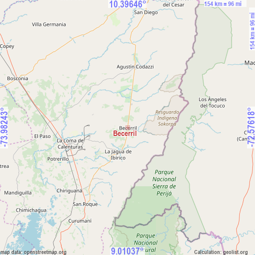
Becerril GPS coordinates[2]
9° 42' 14.868" North, 73° 16' 45.48" West
| Map corner | latitude | longitude |
|---|---|---|
| Upper-left | 10.39646°, | -73.98243° |
| Center: | 9.70413°, | -73.2793° |
| Lower-right: | 9.01037°, | -72.57618° |
| Map W x H: | 154.1×154.1 km | = 95.8×95.8mi |
| max Lat: | 13.38166° ⇑8.4% North |
| Becerril: | 9.70413° |
| min Lat: | ⇓91.6% South -4.21528° |
| min Long | Becerril | max Long |
| -81.70636° | -73.2793° | -67.06996° |
| W 81.2%⇐ | ⇒18.8% E |
Elevation
Elevation of Becerril is 112 m = 367 ft, and this is 1037.3 m = 3403 ft below average elevation for this country.
| Max E: |
3342 m = 10965 ft | 80.2% |
| Avg. | 1149.3 m = 3771 ft | |
| Becerril | 112 m = 367 ft | |
Min E: |
1 m = 3 ft | 19.8% |
See also: Colombia elevation on elevation.city.
Geographical zone
Becerril is located in North Torrid zone (between Equator and Tropic of Cancer). Distance of Equator is 1079 km =670.5 mi to South.| Distance of | km | miles | from Becerril |
|---|---|---|---|
| North Pole | 8928.1 | 5547.7 | to North |
| Arctic Circle | 6322.2 | 3928.4 | to North |
| Tropic Cancer | 1526.9 | 948.8 | to North |
| Equator | 1079 | 670.5 | to South |


Nearby cities:
15 places around Becerril: (largest is in red/bold)
• Agustín Codazzi
37.3 km =23.2 mi,  7°
7°
• Astrea
79.7 km =49.5 mi,  253°
253°
• Bosconia
73 km =45.4 mi,  293°
293°
• Chimichagua
76.7 km =47.7 mi,  229°
229°
• Chiriguaná
52 km =32.3 mi,  223°
223°
• Curumaní
63.1 km =39.2 mi,  207°
207°
• El Copey
89.7 km =55.7 mi,  303°
303°
• El Paso
51.5 km =32 mi,  264°
264°
• La Jagua de Ibirico
16.9 km =10.5 mi,  200°
200°
• La Paz
76.5 km =47.5 mi, 8°
• Manaure Balcón del Cesar
81.2 km =50.5 mi,  19°
19°
• Pailitas
91.4 km =56.8 mi, 204°
• Pueblo Bello
85.9 km =53.4 mi,  337°
337°
• San Diego
71.1 km =44.2 mi, 8°
• Valledupar
84.4 km =52.4 mi,  1°
1°
Sources, notices
• [Note1] Compared only with cities in Colombia existing in our database
• [Src1] Map data: © OpenStreetMap contributors (CC-BY-SA)
• [Src2] Other city data from geonames.org with taken over terms of usage.
• [Src3] Geographical zone / Annual Mean Temperature by Robert A. Rohde @ Wikipedia
