El Copey geodata
El Copey (Cesar) is a seat of a second-order administrative division; located in Colombia in America/Bogota (GMT-5) time zone. With population of 18,136 people, there are 196 cities with bigger population in this country. Compared to other cities in Colombia, 93.3% of cities are located further ↓South; 65.8% of cities are located further ←West and 78% of cities have higher elevation than El Copey. Note1


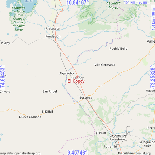
El Copey GPS coordinates[2]
10° 9' 1.116" North, 73° 57' 41.04" West
| Map corner | latitude | longitude |
|---|---|---|
| Upper-left | 10.84167°, | -74.66453° |
| Center: | 10.15031°, | -73.9614° |
| Lower-right: | 9.45746°, | -73.25828° |
| Map W x H: | 153.9×153.9 km | = 95.6×95.6mi |
| max Lat: | 13.38166° ⇑6.7% North |
| El Copey: | 10.15031° |
| min Lat: | ⇓93.3% South -4.21528° |
| min Long | El Copey | max Long |
| -81.70636° | -73.9614° | -67.06996° |
| W 65.8%⇐ | ⇒34.2% E |
Elevation
Elevation of El Copey is 141 m = 463 ft, and this is 1008.3 m = 3308 ft below average elevation for this country.
| Max E: |
3342 m = 10965 ft | 78% |
| Avg. | 1149.3 m = 3771 ft | |
| El Copey | 141 m = 463 ft | |
Min E: |
1 m = 3 ft | 22% |
See also: Colombia elevation on elevation.city.
Geographical zone
El Copey is located in North Torrid zone (between Equator and Tropic of Cancer). Distance of Equator is 1128.6 km =701.3 mi to South.| Distance of | km | miles | from El Copey |
|---|---|---|---|
| North Pole | 8878.5 | 5516.8 | to North |
| Arctic Circle | 6272.6 | 3897.6 | to North |
| Tropic Cancer | 1477.3 | 918 | to North |
| Equator | 1128.6 | 701.3 | to South |


Nearby cities:
15 places around El Copey: (largest is in red/bold)
• Algarrobo
11.6 km =7.2 mi,  290°
290°
• Algarrobo
67.3 km =41.8 mi,  273°
273°
• Aracataca
55.1 km =34.2 mi,  333°
333°
• Ariguaní
11.9 km =7.4 mi,  339°
339°
• Astrea
72.5 km =45 mi,  181°
181°
• Bosconia
21.5 km =13.4 mi,  158°
158°
• Concordia
64.4 km =40 mi,  237°
237°
• El Difícil
45 km =28 mi,  222°
222°
• El Paso
59.6 km =37 mi, 156°
• El Retén
61.3 km =38.1 mi, 326°
• Fundación
47.9 km =29.8 mi, 329°
• Nueva Granada
61.1 km =38 mi,  230°
230°
• Prado-Sevilla
70.9 km =44.1 mi, 344°
• Pueblo Bello
51.2 km =31.8 mi,  54°
54°
• San Ángel
30.8 km =19.1 mi, 244°
Sources, notices
• [Note1] Compared only with cities in Colombia existing in our database
• [Src1] Map data: © OpenStreetMap contributors (CC-BY-SA)
• [Src2] Other city data from geonames.org with taken over terms of usage.
• [Src3] Geographical zone / Annual Mean Temperature by Robert A. Rohde @ Wikipedia
