San Vicente del Caguán geodata
San Vicente del Caguán (Caquetá) is a seat of a second-order administrative division; located in Colombia in America/Bogota (GMT-5) time zone. In our database, there are 1053 cities with bigger population. Compared to other cities in Colombia, 89.1% of cities are located further ↑North; 51.5% of cities are located further ←West and 70.7% of cities have higher elevation than San Vicente del Caguán. Note1


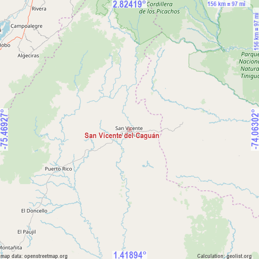
San Vicente del Caguán GPS coordinates[2]
2° 7' 18.192" North, 74° 45' 58.104" West
| Map corner | latitude | longitude |
|---|---|---|
| Upper-left | 2.82419°, | -75.46927° |
| Center: | 2.12172°, | -74.76614° |
| Lower-right: | 1.41894°, | -74.06302° |
| Map W x H: | 156.2×156.3 km | = 97.1×97.1mi |
| max Lat: | 13.38166° ⇑89.1% North |
| San Vicente del Caguán: | 2.12172° |
| min Lat: | ⇓10.9% South -4.21528° |
| min Long | San Vicente del | max Long |
| -81.70636° | -74.76614° | -67.06996° |
| W 51.5%⇐ | ⇒48.5% E |
Elevation
Elevation of San Vicente del Caguán is 280 m = 919 ft, and this is 869.3 m = 2852 ft below average elevation for this country.
| Max E: |
3342 m = 10965 ft | 70.7% |
| Avg. | 1149.3 m = 3771 ft | |
| San Vicente del Caguán | 280 m = 919 ft | |
Min E: |
1 m = 3 ft | 29.3% |
See also: Colombia elevation on elevation.city.
Geographical zone
San Vicente del Caguán is located in North Torrid zone (between Equator and Tropic of Cancer). Distance of Equator is 235.9 km =146.6 mi to South.| Distance of | km | miles | from San Vicente del Caguán |
|---|---|---|---|
| North Pole | 9771.1 | 6071.5 | to North |
| Arctic Circle | 7165.3 | 4452.3 | to North |
| Tropic Cancer | 2370 | 1472.6 | to North |
| Equator | 235.9 | 146.6 | to South |


Nearby cities:
15 places around San Vicente del Caguán: (largest is in red/bold)
• Algeciras
75.8 km =47.1 mi,  306°
306°
• Campoalegre
88 km =54.7 mi,  315°
315°
• Cartagena del Chairá
87.9 km =54.6 mi,  185°
185°
• El Doncello
75.8 km =47.1 mi,  229°
229°
• El Paujíl
87.6 km =54.4 mi, 225°
• Florencia
109.1 km =67.8 mi,  238°
238°
• Garzón
96.1 km =59.7 mi,  274°
274°
• Gigante
91.7 km =57 mi,  288°
288°
• Hobo
91.7 km =57 mi,  304°
304°
• La Macarena
109 km =67.7 mi,  86°
86°
• La Montañita
103.2 km =64.1 mi, 226°
• Neiva
106.3 km =66.1 mi,  327°
327°
• Puerto Rico
49.6 km =30.8 mi, 241°
• Rivera
91 km =56.5 mi, 323°
• Yaguará
102.9 km =63.9 mi, 305°
Sources, notices
• [Note1] Compared only with cities in Colombia existing in our database
• [Src1] Map data: © OpenStreetMap contributors (CC-BY-SA)
• [Src2] Other city data from geonames.org with taken over terms of usage.
• [Src3] Geographical zone / Annual Mean Temperature by Robert A. Rohde @ Wikipedia
