Puerto Rico geodata
Puerto Rico (Caquetá) is a seat of a second-order administrative division; located in Colombia in America/Bogota (GMT-5) time zone. With population of 12,306 people, there are 253 cities with bigger population in this country. Compared to other cities in Colombia, 90.9% of cities are located further ↑North; 58.3% of cities are located further →East and 63.5% of cities have higher elevation than Puerto Rico. Note1


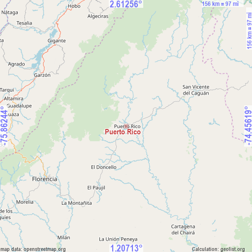
Puerto Rico GPS coordinates[2]
1° 54' 35.964" North, 75° 9' 33.516" West
| Map corner | latitude | longitude |
|---|---|---|
| Upper-left | 2.61256°, | -75.86244° |
| Center: | 1.90999°, | -75.15931° |
| Lower-right: | 1.20713°, | -74.45619° |
| Map W x H: | 156.3×156.3 km | = 97.1×97.1mi |
| max Lat: | 13.38166° ⇑90.9% North |
| Puerto Rico: | 1.90999° |
| min Lat: | ⇓9.1% South -4.21528° |
| min Long | Puerto Rico | max Long |
| -81.70636° | -75.15931° | -67.06996° |
| W 41.7%⇐ | ⇒58.3% E |
Elevation
Elevation of Puerto Rico is 531 m = 1742 ft, and this is 618.3 m = 2029 ft below average elevation for this country.
| Max E: |
3342 m = 10965 ft | 63.5% |
| Avg. | 1149.3 m = 3771 ft | |
| Puerto Rico | 531 m = 1742 ft | |
Min E: |
1 m = 3 ft | 36.5% |
See also: Colombia elevation on elevation.city.
Geographical zone
Puerto Rico is located in North Torrid zone (between Equator and Tropic of Cancer). Distance of Equator is 212.4 km =132 mi to South.| Distance of | km | miles | from Puerto Rico |
|---|---|---|---|
| North Pole | 9794.7 | 6086.1 | to North |
| Arctic Circle | 7188.8 | 4466.9 | to North |
| Tropic Cancer | 2393.5 | 1487.3 | to North |
| Equator | 212.4 | 132 | to South |


Nearby cities:
15 places around Puerto Rico: (largest is in red/bold)
• Agrado
78.2 km =48.6 mi,  299°
299°
• Algeciras
70.5 km =43.8 mi,  345°
345°
• Altamira
71.8 km =44.6 mi,  283°
283°
• Cartagena del Chairá
73 km =45.4 mi,  151°
151°
• El Doncello
29.3 km =18.2 mi,  208°
208°
• El Paujíl
42.2 km =26.2 mi, 206°
• Florencia
59.6 km =37 mi,  236°
236°
• Garzón
61 km =37.9 mi, 301°
• Gigante
68.3 km =42.4 mi,  320°
320°
• Guadalupe
67.5 km =41.9 mi, 280°
• La Montañita
56.9 km =35.4 mi, 212°
• Morelia
78.6 km =48.8 mi,  233°
233°
• San Vicente del Caguán
49.6 km =30.8 mi,  61°
61°
• Suaza
71 km =44.1 mi, 275°
• Tarqui
77.2 km =48 mi,  286°
286°
Sources, notices
• [Note1] Compared only with cities in Colombia existing in our database
• [Src1] Map data: © OpenStreetMap contributors (CC-BY-SA)
• [Src2] Other city data from geonames.org with taken over terms of usage.
• [Src3] Geographical zone / Annual Mean Temperature by Robert A. Rohde @ Wikipedia
