La Esperanza geodata
La Esperanza (Norte de Santander) is a populated place; located in Colombia in America/Bogota (GMT-5) time zone. With population of 2,718 people, there are 711 cities with bigger population in this country. Compared to other cities in Colombia, 81.6% of cities are located further ↓South; 96.2% of cities are located further ←West and 83.4% of cities have higher elevation than La Esperanza. Note1


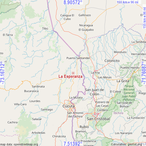
La Esperanza GPS coordinates[2]
8° 12' 37.548" North, 72° 27' 50.364" West
| Map corner | latitude | longitude |
|---|---|---|
| Upper-left | 8.90572°, | -73.16712° |
| Center: | 8.21043°, | -72.46399° |
| Lower-right: | 7.51392°, | -71.76087° |
| Map W x H: | 154.8×154.8 km | = 96.2×96.2mi |
| max Lat: | 13.38166° ⇑18.4% North |
| La Esperanza: | 8.21043° |
| min Lat: | ⇓81.6% South -4.21528° |
| min Long | La Esperanza | max Long |
| -81.70636° | -72.46399° | -67.06996° |
| W 96.2%⇐ | ⇒3.8% E |
Elevation
Elevation of La Esperanza is 81 m = 266 ft, and this is 1068.3 m = 3505 ft below average elevation for this country.
| Max E: |
3342 m = 10965 ft | 83.4% |
| Avg. | 1149.3 m = 3771 ft | |
| La Esperanza | 81 m = 266 ft | |
Min E: |
1 m = 3 ft | 16.6% |
See also: Colombia elevation on elevation.city.
Geographical zone
La Esperanza is located in North Torrid zone (between Equator and Tropic of Cancer). Distance of Equator is 912.9 km =567.2 mi to South.| Distance of | km | miles | from La Esperanza |
|---|---|---|---|
| North Pole | 9094.1 | 5650.8 | to North |
| Arctic Circle | 6488.3 | 4031.6 | to North |
| Tropic Cancer | 1693 | 1052 | to North |
| Equator | 912.9 | 567.2 | to South |


Nearby cities:
15 places around La Esperanza: (largest is in red/bold)
• Bucarasica
48 km =29.8 mi,  246°
246°
• Chinácota
68.7 km =42.7 mi,  192°
192°
• Cúcuta
35.5 km =22.1 mi, 187°
• Durania
59.3 km =36.8 mi,  201°
201°
• El Zulia
34.4 km =21.4 mi,  206°
206°
• Gramalote
51.4 km =31.9 mi,  225°
225°
• Los Patios
41.6 km =25.8 mi, 186°
• Lourdes
50.2 km =31.2 mi, 233°
• Puerto Santander
18.2 km =11.3 mi,  20°
20°
• San Cayetano
41.1 km =25.5 mi, 205°
• Santiago
47.5 km =29.5 mi,  215°
215°
• Sardinata
39.7 km =24.7 mi, 249°
• Tibú
56.3 km =35 mi,  327°
327°
• Villa Caro
64.8 km =40.3 mi,  239°
239°
• Villa del Rosario
41.9 km =26 mi,  181°
181°
Sources, notices
• [Note1] Compared only with cities in Colombia existing in our database
• [Src1] Map data: © OpenStreetMap contributors (CC-BY-SA)
• [Src2] Other city data from geonames.org with taken over terms of usage.
• [Src3] Geographical zone / Annual Mean Temperature by Robert A. Rohde @ Wikipedia
