Jordán geodata
Jordán (Santander) is a seat of a second-order administrative division; located in Colombia in America/Bogota (GMT-5) time zone. With population of 112 people, there are 1052 cities with bigger population in this country. Compared to other cities in Colombia, 71.9% of cities are located further ↓South; 84.9% of cities are located further ←West and 65.2% of cities have higher elevation than Jordán. Note1


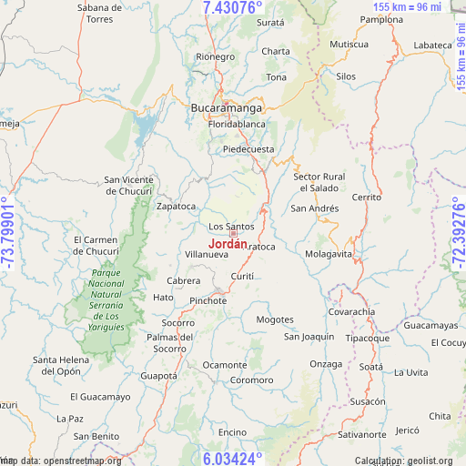
Jordán GPS coordinates[2]
6° 43' 58.8" North, 73° 5' 45.168" West
| Map corner | latitude | longitude |
|---|---|---|
| Upper-left | 7.43076°, | -73.79901° |
| Center: | 6.733°, | -73.09588° |
| Lower-right: | 6.03424°, | -72.39276° |
| Map W x H: | 155.3×155.3 km | = 96.5×96.5mi |
| max Lat: | 13.38166° ⇑28.1% North |
| Jordán: | 6.733° |
| min Lat: | ⇓71.9% South -4.21528° |
| min Long | Jordán | max Long |
| -81.70636° | -73.09588° | -67.06996° |
| W 84.9%⇐ | ⇒15.1% E |
Elevation
Elevation of Jordán is 438 m = 1437 ft, and this is 711.3 m = 2334 ft below average elevation for this country.
| Max E: |
3342 m = 10965 ft | 65.2% |
| Avg. | 1149.3 m = 3771 ft | |
| Jordán | 438 m = 1437 ft | |
Min E: |
1 m = 3 ft | 34.8% |
See also: Colombia elevation on elevation.city.
Geographical zone
Jordán is located in North Torrid zone (between Equator and Tropic of Cancer). Distance of Equator is 748.6 km =465.2 mi to South.| Distance of | km | miles | from Jordán |
|---|---|---|---|
| North Pole | 9258.4 | 5752.9 | to North |
| Arctic Circle | 6652.5 | 4133.7 | to North |
| Tropic Cancer | 1857.3 | 1154.1 | to North |
| Equator | 748.6 | 465.2 | to South |


Nearby cities:
15 places around Jordán: (largest is in red/bold)
• Aratoca
9.5 km =5.9 mi,  116°
116°
• Barichara
17.7 km =11 mi,  232°
232°
• Betulia
27.9 km =17.3 mi,  311°
311°
• Cabrera
22.8 km =14.2 mi, 226°
• Cepitá
13.6 km =8.5 mi,  80°
80°
• Curití
14.5 km =9 mi,  167°
167°
• Galán
23.8 km =14.8 mi,  243°
243°
• Los Santos
2.5 km =1.6 mi,  336°
336°
• Palmar
30.7 km =19.1 mi,  224°
224°
• Piedecuesta
28.8 km =17.9 mi,  10°
10°
• Pinchote
23.9 km =14.9 mi,  200°
200°
• San Andrés
28.6 km =17.8 mi,  72°
72°
• San Gil
19.8 km =12.3 mi,  193°
193°
• Villanueva
11 km =6.8 mi, 231°
• Zapatoca
21.1 km =13.1 mi,  295°
295°
Sources, notices
• [Note1] Compared only with cities in Colombia existing in our database
• [Src1] Map data: © OpenStreetMap contributors (CC-BY-SA)
• [Src2] Other city data from geonames.org with taken over terms of usage.
• [Src3] Geographical zone / Annual Mean Temperature by Robert A. Rohde @ Wikipedia
