Herrán geodata
Herrán (Norte de Santander) is a seat of a second-order administrative division; located in Colombia in America/Bogota (GMT-5) time zone. With population of 1,648 people, there are 845 cities with bigger population in this country. Compared to other cities in Colombia, 78.1% of cities are located further ↓South; 95.8% of cities are located further ←West and 77.8% of cities have lower elevation than Herrán. Note1


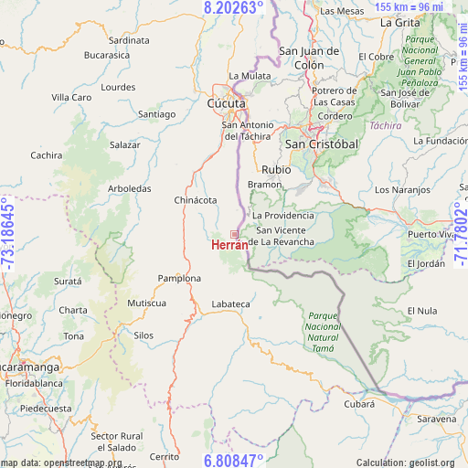
Herrán GPS coordinates[2]
7° 30' 21.996" North, 72° 28' 59.952" West
| Map corner | latitude | longitude |
|---|---|---|
| Upper-left | 8.20263°, | -73.18645° |
| Center: | 7.50611°, | -72.48332° |
| Lower-right: | 6.80847°, | -71.7802° |
| Map W x H: | 155×155 km | = 96.3×96.3mi |
| max Lat: | 13.38166° ⇑21.9% North |
| Herrán: | 7.50611° |
| min Lat: | ⇓78.1% South -4.21528° |
| min Long | Herrán | max Long |
| -81.70636° | -72.48332° | -67.06996° |
| W 95.8%⇐ | ⇒4.2% E |
Elevation
Elevation of Herrán is 1960 m = 6430 ft, and this is 810.7 m = 2660 ft above average elevation for this country.
| Max E: |
3342 m = 10965 ft | 22.2% |
| Herrán | 1960 m 6430 ft | |
| Avg. | 1149.3 m = 3771 ft | |
Min E: |
1 m = 3 ft | 77.8% |
See also: Colombia elevation on elevation.city.
Geographical zone
Herrán is located in North Torrid zone (between Equator and Tropic of Cancer). Distance of Equator is 834.6 km =518.6 mi to South.| Distance of | km | miles | from Herrán |
|---|---|---|---|
| North Pole | 9172.5 | 5699.5 | to North |
| Arctic Circle | 6566.6 | 4080.3 | to North |
| Tropic Cancer | 1771.3 | 1100.6 | to North |
| Equator | 834.6 | 518.6 | to South |


Nearby cities:
15 places around Herrán: (largest is in red/bold)
• Arboledas
38 km =23.6 mi,  293°
293°
• Bochalema
21.5 km =13.4 mi,  302°
302°
• Chinácota
17.2 km =10.7 mi,  310°
310°
• Cucutilla
32.1 km =19.9 mi,  276°
276°
• Cácota
31.7 km =19.7 mi,  213°
213°
• Cúcuta
43.2 km =26.8 mi,  356°
356°
• Durania
30 km =18.6 mi,  320°
320°
• Labateca
23.1 km =14.4 mi,  183°
183°
• Los Patios
37 km =23 mi, 356°
• Mutiscua
36.9 km =22.9 mi,  231°
231°
• Pamplona
23.2 km =14.4 mi, 231°
• Pamplonita
18.7 km =11.6 mi,  245°
245°
• Ragonvalia
8 km =5 mi,  6°
6°
• Toledo
21.8 km =13.5 mi, 179°
• Villa del Rosario
36.5 km =22.7 mi,  1°
1°
Sources, notices
• [Note1] Compared only with cities in Colombia existing in our database
• [Src1] Map data: © OpenStreetMap contributors (CC-BY-SA)
• [Src2] Other city data from geonames.org with taken over terms of usage.
• [Src3] Geographical zone / Annual Mean Temperature by Robert A. Rohde @ Wikipedia
