Manizales geodata
Manizales (Caldas) is a seat of a first-order administrative division; located in Colombia in America/Bogota (GMT-5) time zone. With population of 357,814 people, there are 12 cities with bigger population in this country. Compared to other cities in Colombia, 60.3% of cities are located further ↑North; 66.9% of cities are located further →East and 81.6% of cities have lower elevation than Manizales. Note1


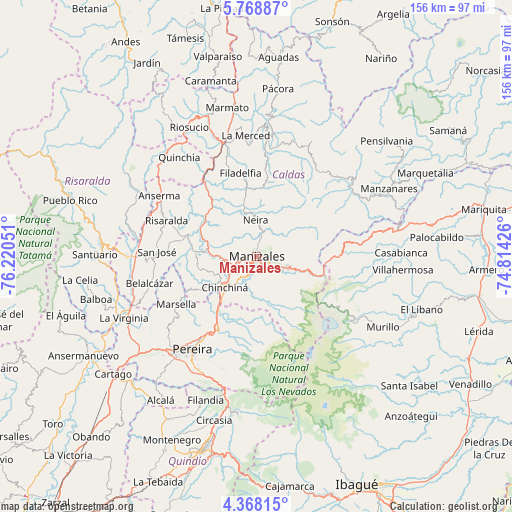
Manizales GPS coordinates[2]
5° 4' 8.004" North, 75° 31' 2.568" West
| Map corner | latitude | longitude |
|---|---|---|
| Upper-left | 5.76887°, | -76.22051° |
| Center: | 5.06889°, | -75.51738° |
| Lower-right: | 4.36815°, | -74.81426° |
| Map W x H: | 155.7×155.7 km | = 96.7×96.7mi |
| max Lat: | 13.38166° ⇑60.3% North |
| Manizales: | 5.06889° |
| min Lat: | ⇓39.7% South -4.21528° |
| min Long | Manizales | max Long |
| -81.70636° | -75.51738° | -67.06996° |
| W 33.1%⇐ | ⇒66.9% E |
Elevation
Elevation of Manizales is 2119 m = 6952 ft, and this is 969.7 m = 3181 ft above average elevation for this country.
| Max E: |
3342 m = 10965 ft | 18.4% |
| Manizales | 2119 m 6952 ft | |
| Avg. | 1149.3 m = 3771 ft | |
Min E: |
1 m = 3 ft | 81.6% |
See also: Manizales elevation on elevation.city.
Geographical zone
Manizales is located in North Torrid zone (between Equator and Tropic of Cancer). Distance of Equator is 563.6 km =350.2 mi to South.| Distance of | km | miles | from Manizales |
|---|---|---|---|
| North Pole | 9443.5 | 5867.9 | to North |
| Arctic Circle | 6837.6 | 4248.7 | to North |
| Tropic Cancer | 2042.3 | 1269 | to North |
| Equator | 563.6 | 350.2 | to South |


Nearby cities:
15 places around Manizales: (largest is in red/bold)
• Anserma
34.9 km =21.7 mi,  301°
301°
• Aranzazu
22.7 km =14.1 mi,  7°
7°
• Belalcázar
33.7 km =20.9 mi,  255°
255°
• Chinchiná
13.5 km =8.4 mi,  224°
224°
• Dosquebradas
30.5 km =19 mi,  213°
213°
• Filadelfia
25.7 km =16 mi,  349°
349°
• La Merced
36.9 km =22.9 mi, 354°
• Marsella
28.5 km =17.7 mi,  239°
239°
• Neira
10.9 km =6.8 mi,  358°
358°
• Palestina
13.6 km =8.5 mi, 244°
• Pereira
34.6 km =21.5 mi, 214°
• Risaralda
29.6 km =18.4 mi,  291°
291°
• San José
30.3 km =18.8 mi,  272°
272°
• Santa Rosa de Cabal
25.1 km =15.6 mi, 207°
• Villamaría
2.6 km =1.6 mi,  173°
173°
Sources, notices
• [Note1] Compared only with cities in Colombia existing in our database
• [Src1] Map data: © OpenStreetMap contributors (CC-BY-SA)
• [Src2] Other city data from geonames.org with taken over terms of usage.
• [Src3] Geographical zone / Annual Mean Temperature by Robert A. Rohde @ Wikipedia
