Marulanda geodata
Marulanda (Caldas) is a seat of a second-order administrative division; located in Colombia in America/Bogota (GMT-5) time zone. With population of 1,256 people, there are 907 cities with bigger population in this country. Compared to other cities in Colombia, 55.3% of cities are located further ↑North; 60.6% of cities are located further →East and 97.7% of cities have lower elevation than Marulanda. Note1


Marulanda GPS coordinates[2]
5° 17' 2.148" North, 75° 15' 36.576" West
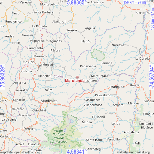
| Map corner | latitude | longitude |
|---|---|---|
| Upper-left | 5.98365°, | -75.96329° |
| Center: | 5.28393°, | -75.26016° |
| Lower-right: | 4.58341°, | -74.55704° |
| Map W x H: | 155.7×155.7 km | = 96.7×96.7mi |
| max Lat: | 13.38166° ⇑55.3% North |
| Marulanda: | 5.28393° |
| min Lat: | ⇓44.7% South -4.21528° |
| min Long | Marulanda | max Long |
| -81.70636° | -75.26016° | -67.06996° |
| W 39.4%⇐ | ⇒60.6% E |
Elevation
Elevation of Marulanda is 2858 m = 9377 ft, and this is 1708.7 m = 5606 ft above average elevation for this country.
| Max E: |
3342 m = 10965 ft | 2.3% |
| Marulanda | 2858 m 9377 ft | |
| Avg. | 1149.3 m = 3771 ft | |
Min E: |
1 m = 3 ft | 97.7% |
See also: Colombia elevation on elevation.city.
Geographical zone
Marulanda is located in North Torrid zone (between Equator and Tropic of Cancer). Distance of Equator is 587.5 km =365.1 mi to South.| Distance of | km | miles | from Marulanda |
|---|---|---|---|
| North Pole | 9419.5 | 5853 | to North |
| Arctic Circle | 6813.7 | 4233.8 | to North |
| Tropic Cancer | 2018.4 | 1254.2 | to North |
| Equator | 587.5 | 365.1 | to South |


Nearby cities:
15 places around Marulanda: (largest is in red/bold)
• Aranzazu
25.5 km =15.8 mi,  266°
266°
• Casabianca
27.5 km =17.1 mi,  145°
145°
• Filadelfia
33.4 km =20.8 mi, 272°
• Fresno
28.8 km =17.9 mi,  120°
120°
• Herveo
24.5 km =15.2 mi,  157°
157°
• La Merced
34.3 km =21.3 mi,  292°
292°
• Manzanares
12.2 km =7.6 mi,  105°
105°
• Marquetalia
22.8 km =14.2 mi,  86°
86°
• Neira
31.6 km =19.6 mi,  245°
245°
• Padua
21.3 km =13.2 mi,  141°
141°
• Palocabildo
32.7 km =20.3 mi, 124°
• Pensilvania
15.6 km =9.7 mi,  44°
44°
• Salamina
28.7 km =17.8 mi,  298°
298°
• Samaná
32.9 km =20.4 mi,  64°
64°
• Villahermosa
32.4 km =20.1 mi, 150°
Sources, notices
• [Note1] Compared only with cities in Colombia existing in our database
• [Src1] Map data: © OpenStreetMap contributors (CC-BY-SA)
• [Src2] Other city data from geonames.org with taken over terms of usage.
• [Src3] Geographical zone / Annual Mean Temperature by Robert A. Rohde @ Wikipedia
