Neira geodata
Neira (Caldas) is a seat of a second-order administrative division; located in Colombia in America/Bogota (GMT-5) time zone. With population of 11,755 people, there are 258 cities with bigger population in this country. Compared to other cities in Colombia, 58.1% of cities are located further ↑North; 67.1% of cities are located further →East and 77.6% of cities have lower elevation than Neira. Note1


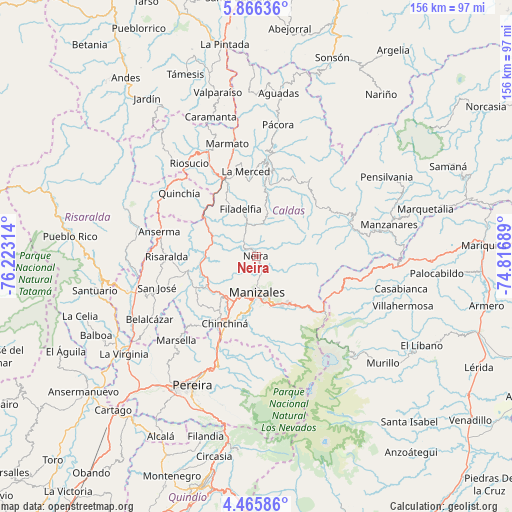
Neira GPS coordinates[2]
5° 9' 59.4" North, 75° 31' 12.036" West
| Map corner | latitude | longitude |
|---|---|---|
| Upper-left | 5.86636°, | -76.22314° |
| Center: | 5.1665°, | -75.52001° |
| Lower-right: | 4.46586°, | -74.81689° |
| Map W x H: | 155.7×155.7 km | = 96.7×96.7mi |
| max Lat: | 13.38166° ⇑58.1% North |
| Neira: | 5.1665° |
| min Lat: | ⇓41.9% South -4.21528° |
| min Long | Neira | max Long |
| -81.70636° | -75.52001° | -67.06996° |
| W 32.9%⇐ | ⇒67.1% E |
Elevation
Elevation of Neira is 1953 m = 6407 ft, and this is 803.7 m = 2637 ft above average elevation for this country.
| Max E: |
3342 m = 10965 ft | 22.4% |
| Neira | 1953 m 6407 ft | |
| Avg. | 1149.3 m = 3771 ft | |
Min E: |
1 m = 3 ft | 77.6% |
See also: Colombia elevation on elevation.city.
Geographical zone
Neira is located in North Torrid zone (between Equator and Tropic of Cancer). Distance of Equator is 574.5 km =357 mi to South.| Distance of | km | miles | from Neira |
|---|---|---|---|
| North Pole | 9432.6 | 5861.1 | to North |
| Arctic Circle | 6826.7 | 4241.9 | to North |
| Tropic Cancer | 2031.5 | 1262.3 | to North |
| Equator | 574.5 | 357 | to South |


Nearby cities:
15 places around Neira: (largest is in red/bold)
• Anserma
30.3 km =18.8 mi,  284°
284°
• Aranzazu
12.1 km =7.5 mi,  15°
15°
• Chinchiná
22.5 km =14 mi,  204°
204°
• Filadelfia
15.1 km =9.4 mi,  342°
342°
• La Merced
26.1 km =16.2 mi,  353°
353°
• Manizales
10.9 km =6.8 mi,  178°
178°
• Marulanda
31.6 km =19.6 mi,  65°
65°
• Palestina
20.6 km =12.8 mi,  215°
215°
• Quinchía
30.2 km =18.8 mi,  309°
309°
• Riosucio
34.9 km =21.7 mi,  324°
324°
• Risaralda
27.2 km =16.9 mi,  269°
269°
• Salamina
27 km =16.8 mi,  7°
7°
• San José
31.4 km =19.5 mi,  252°
252°
• Santa Rosa de Cabal
35 km =21.7 mi, 198°
• Villamaría
13.4 km =8.3 mi, 177°
Sources, notices
• [Note1] Compared only with cities in Colombia existing in our database
• [Src1] Map data: © OpenStreetMap contributors (CC-BY-SA)
• [Src2] Other city data from geonames.org with taken over terms of usage.
• [Src3] Geographical zone / Annual Mean Temperature by Robert A. Rohde @ Wikipedia
