Gigante geodata
Gigante (Huila) is a populated place; located in Colombia in America/Bogota (GMT-5) time zone. With population of 9,829 people, there are 312 cities with bigger population in this country. Compared to other cities in Colombia, 87.9% of cities are located further ↑North; 67.6% of cities are located further →East and 59.4% of cities have higher elevation than Gigante. Note1


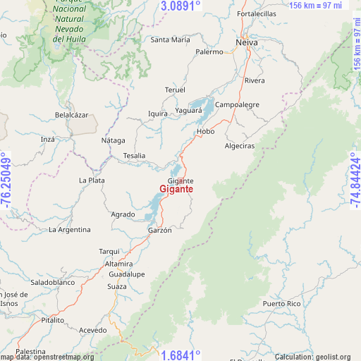
Gigante GPS coordinates[2]
2° 23' 12.408" North, 75° 32' 50.496" West
| Map corner | latitude | longitude |
|---|---|---|
| Upper-left | 3.0891°, | -76.25049° |
| Center: | 2.38678°, | -75.54736° |
| Lower-right: | 1.6841°, | -74.84424° |
| Map W x H: | 156.2×156.2 km | = 97.1×97.1mi |
| max Lat: | 13.38166° ⇑87.9% North |
| Gigante: | 2.38678° |
| min Lat: | ⇓12.1% South -4.21528° |
| min Long | Gigante | max Long |
| -81.70636° | -75.54736° | -67.06996° |
| W 32.4%⇐ | ⇒67.6% E |
Elevation
Elevation of Gigante is 808 m = 2651 ft, and this is 341.3 m = 1120 ft below average elevation for this country.
| Max E: |
3342 m = 10965 ft | 59.4% |
| Avg. | 1149.3 m = 3771 ft | |
| Gigante | 808 m = 2651 ft | |
Min E: |
1 m = 3 ft | 40.6% |
See also: Colombia elevation on elevation.city.
Geographical zone
Gigante is located in North Torrid zone (between Equator and Tropic of Cancer). Distance of Equator is 265.4 km =164.9 mi to South.| Distance of | km | miles | from Gigante |
|---|---|---|---|
| North Pole | 9741.7 | 6053.2 | to North |
| Arctic Circle | 7135.8 | 4434 | to North |
| Tropic Cancer | 2340.5 | 1454.3 | to North |
| Equator | 265.4 | 164.9 | to South |


Nearby cities:
15 places around Gigante: (largest is in red/bold)
• Agrado
28.8 km =17.9 mi,  239°
239°
• Algeciras
29.8 km =18.5 mi,  59°
59°
• Altamira
44.8 km =27.8 mi,  216°
216°
• Campoalegre
41.5 km =25.8 mi,  36°
36°
• Garzón
23 km =14.3 mi,  202°
202°
• Hobo
24.4 km =15.2 mi,  26°
26°
• La Plata
38.3 km =23.8 mi,  271°
271°
• Nátaga
33.8 km =21 mi,  301°
301°
• Paicol
26.2 km =16.3 mi,  285°
285°
• Pital
31.5 km =19.6 mi, 244°
• Tarqui
43.3 km =26.9 mi,  225°
225°
• Teruel
39.6 km =24.6 mi,  356°
356°
• Tesalia
23 km =14.3 mi, 298°
• Yaguará
31 km =19.3 mi,  6°
6°
• Íquira
30.7 km =19.1 mi,  341°
341°
Sources, notices
• [Note1] Compared only with cities in Colombia existing in our database
• [Src1] Map data: © OpenStreetMap contributors (CC-BY-SA)
• [Src2] Other city data from geonames.org with taken over terms of usage.
• [Src3] Geographical zone / Annual Mean Temperature by Robert A. Rohde @ Wikipedia
