Montecristo geodata
Montecristo (Bolívar) is a seat of a second-order administrative division; located in Colombia in America/Bogota (GMT-5) time zone. With population of 5,608 people, there are 470 cities with bigger population in this country. Compared to other cities in Colombia, 82.5% of cities are located further ↓South; 57.2% of cities are located further ←West and 83.1% of cities have higher elevation than Montecristo. Note1


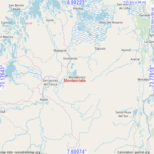
Montecristo GPS coordinates[2]
8° 17' 49.56" North, 74° 28' 23.88" West
| Map corner | latitude | longitude |
|---|---|---|
| Upper-left | 8.99223°, | -75.17643° |
| Center: | 8.2971°, | -74.4733° |
| Lower-right: | 7.60074°, | -73.77018° |
| Map W x H: | 154.7×154.7 km | = 96.1×96.1mi |
| max Lat: | 13.38166° ⇑17.5% North |
| Montecristo: | 8.2971° |
| min Lat: | ⇓82.5% South -4.21528° |
| min Long | Montecristo | max Long |
| -81.70636° | -74.4733° | -67.06996° |
| W 57.2%⇐ | ⇒42.8% E |
Elevation
Elevation of Montecristo is 84 m = 276 ft, and this is 1065.3 m = 3495 ft below average elevation for this country.
| Max E: |
3342 m = 10965 ft | 83.1% |
| Avg. | 1149.3 m = 3771 ft | |
| Montecristo | 84 m = 276 ft | |
Min E: |
1 m = 3 ft | 16.9% |
See also: Colombia elevation on elevation.city.
Geographical zone
Montecristo is located in North Torrid zone (between Equator and Tropic of Cancer). Distance of Equator is 922.6 km =573.3 mi to South.| Distance of | km | miles | from Montecristo |
|---|---|---|---|
| North Pole | 9084.5 | 5644.8 | to North |
| Arctic Circle | 6478.6 | 4025.6 | to North |
| Tropic Cancer | 1683.4 | 1046 | to North |
| Equator | 922.6 | 573.3 | to South |


Nearby cities:
15 places around Montecristo: (largest is in red/bold)
• Achí
31.7 km =19.7 mi,  343°
343°
• Altos del Rosario
64.6 km =40.1 mi,  31°
31°
• Arenal
61 km =37.9 mi,  72°
72°
• Guaranda
20.2 km =12.6 mi, 339°
• Majagual
32.1 km =19.9 mi,  327°
327°
• Morales
66.6 km =41.4 mi,  92°
92°
• Nechí
40.2 km =25 mi,  235°
235°
• Norosí
54.3 km =33.7 mi,  61°
61°
• Pinillos
69.2 km =43 mi,  0°
0°
• Pueblo Nuevo
53.7 km =33.4 mi,  263°
263°
• San Carlos
65.2 km =40.5 mi,  210°
210°
• San Jacinto del Cauca
27.7 km =17.2 mi, 259°
• Santa Rosa del Sur
59.1 km =36.7 mi,  128°
128°
• Sucre
63.3 km =39.3 mi, 334°
• Tiquisio
36.9 km =22.9 mi,  38°
38°
Sources, notices
• [Note1] Compared only with cities in Colombia existing in our database
• [Src1] Map data: © OpenStreetMap contributors (CC-BY-SA)
• [Src2] Other city data from geonames.org with taken over terms of usage.
• [Src3] Geographical zone / Annual Mean Temperature by Robert A. Rohde @ Wikipedia
